There is something wonderfully Oregon about finding an old covered bridge where you least expect one.
Drive east from Eugene and Springfield on Highway 58, following the road toward the forested foothills of the Cascades, and the scenery gradually loosens its grip on the city. The subdivisions thin out, fir-covered hills begin closing in, and before long the highway reaches the broad water of Dexter Reservoir. Sitting along the shoreline near the small community of Lowell is a white wooden structure that looks as though it belongs on an old postcard.
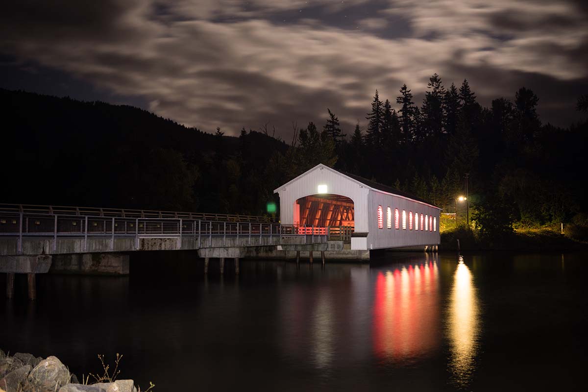
The Lowell Covered Bridge is difficult to miss once you know where to look. Its long white walls stretch over the green-blue water, with tall openings along the sides and a dark entrance framed beneath the pitched roof. On a quiet day, especially when the lake is still, the whole structure can reflect beautifully across the surface.
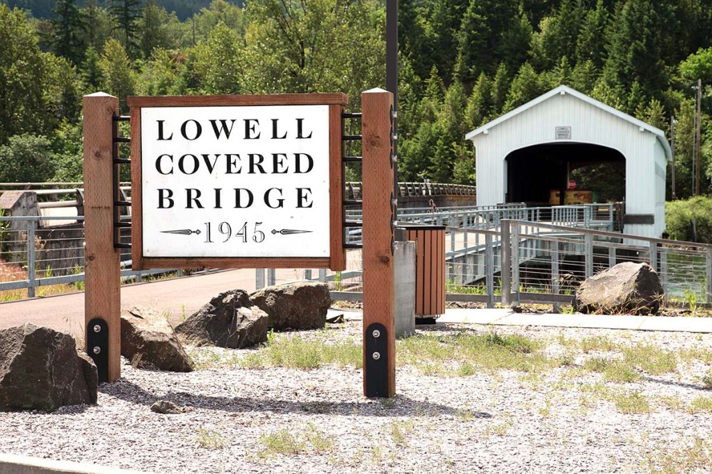
It would be easy to pull over, take a few pictures, admire one of Oregon’s surviving covered bridges and continue toward Oakridge without giving it much more thought.
That would be a shame.
Because this particular bridge has lived an unusually eventful life.
The bridge standing today was built in 1945, but the crossing itself dates to the early 1900s. Over the decades, bridges at this spot have survived changing transportation, logging traffic, damaging truck accidents and one of the largest alterations to the Middle Fork Willamette River landscape in modern Oregon history.
At one point, engineers literally raised the entire bridge six feet into the air because they knew the river below it was about to become a reservoir.
Today the Lowell Covered Bridge no longer carries cars. Instead, it serves as a pedestrian landmark and interpretive center, allowing visitors to walk through a piece of Lane County history that might easily have disappeared decades ago. It is also Oregon’s widest historic covered bridge, with a 24-foot roadway inside its 165-foot span.
And the more you learn about it, the more remarkable it becomes that the old bridge is still here at all.
Before There Was a Bridge, There Was a Ferry
Long before Dexter Reservoir covered this portion of the valley, the Middle Fork Willamette River was simply that, a river winding through farms, timber country and small settlements east of Eugene.
The story of Lowell is closely tied to that river.
Amos Hyland arrived in the area with his family in 1874 and became one of the prominent early landowners around what would eventually become Lowell. The community’s own historical account describes Hyland as a farmer, livestock owner, hop grower and logger who held thousands of acres and later became involved with the Booth-Kelly Lumber Company. A post office was established locally in 1880 under the name Cannon. Within a few years, the name was changed to Lowell, a name associated with Hyland’s earlier home.
Transportation was a very different proposition in those days. Roads were primitive, rivers were serious obstacles, and getting people, animals, wagons and goods from one side of the Middle Fork to the other required a dependable crossing.
At the location where the covered bridge stands today, Hyland operated a ferry.
For residents of the young community, that ferry was not a tourist attraction or quaint piece of pioneer nostalgia. It was infrastructure. Rivers divided neighborhoods, farms and markets, and a reliable way across could shape everything from commerce to ordinary daily travel.
By the early 20th century, however, Lowell was changing.
Railroad construction and the expanding timber industry were transforming the upper Willamette Valley. Sawmills, logging operations and rail lines increasingly connected communities that had once been relatively isolated. The era of relying on a ferry at Lowell was coming to an end.
In 1907, the first covered bridge was constructed at the crossing.
The builder was Nels Roney, a well-known Eugene-area contractor whose work included other prominent Oregon structures. According to historical documentation preserved with the National Register nomination, that original Lowell bridge measured about 210 feet long. It replaced the ferry and gave residents a permanent road connection across the Middle Fork Willamette.
For nearly four decades, that bridge did its job.
Then a truck nearly ended the story.
The official That Oregon Life store
The Oregon you bring home.
Start the day with Oregon-roasted coffee, then find original gear inspired by the places, stories, and oddities that make this state ours.
Shop Oregon gear


One Truck Accident, One New Bridge
Covered bridges have an old-fashioned beauty today, but they were never built merely to look charming.
The familiar walls and roofs were practical engineering.
Lane County explains that covering wooden bridges protected the structural timbers and floor system from Oregon’s relentless rain and other weather. Good timber was plentiful in the Pacific Northwest, while steel and concrete were historically more expensive and difficult to obtain. Protecting a wooden truss beneath a roof could dramatically extend the bridge’s useful life.
That mattered in western Oregon, where months of damp weather can turn exposed wood into a maintenance nightmare.
By the 1940s, however, the first Lowell bridge had another problem.
A truck accident knocked its truss out of alignment and damaged the structure badly enough that replacement became necessary. Rather than attempting to keep the 1907 span functioning indefinitely, Lane County built the bridge visitors see today.
The replacement was completed in 1945 at a reported cost of $25,473. Interestingly, the new bridge was not immediately enclosed. The familiar housing was added two years later, in 1947.
Its design used a Howe truss, a system found in many of Oregon’s surviving covered bridges. In simple terms, the truss forms the structural skeleton that distributes the loads carried by the bridge. The Lowell structure stretches 165 feet and was built wide enough for a 24-foot roadway, an unusually generous width for a covered bridge.
That width would eventually earn it a distinction it still holds today.
The Lowell Covered Bridge is considered the widest covered bridge in Oregon.
The National Register documentation also notes architectural details that are easy to overlook during a casual visit, including its semi-elliptical entrance arches, vertical board-and-batten siding, wooden deck and distinctive openings along the side.
For a few years after construction, the bridge probably seemed ready to settle into an ordinary working life.
Then engineers began preparing to transform the entire river valley around it.
Oregon Was About to Put a Lake Beneath the Bridge
The Lowell Covered Bridge’s most fascinating chapter began not because anything was wrong with the bridge, but because the landscape underneath it was about to change dramatically.
During the middle of the 20th century, the federal government was developing a network of dams throughout the Willamette River basin for flood risk management, power generation and other purposes.
Dexter Dam became part of that enormous effort.
According to the U.S. Army Corps of Engineers, construction of Dexter Dam began in 1947. The structure was built on the Middle Fork Willamette River near Lowell, downstream from Lookout Point Dam. Dexter is a substantial structure, roughly 90 feet high and more than 2,300 feet long, and it now works as part of the larger system of federal dams in the Willamette Valley.
When the dam was completed in 1955, the water backing up behind it would create Dexter Reservoir.
There was just one small problem.
The Lowell Covered Bridge was already sitting down there.
Engineers knew what was coming, so in 1953, two years before Dexter Dam was completed, an extraordinary project unfolded.
The bridge was raised six feet.
Not replaced. Not moved to a museum. Raised.
The roadway was also reconstructed to prepare the crossing for the reservoir that would soon surround it. Historical records say engineers had calculated where the future waterline would reach once Dexter Reservoir filled.
Then everyone waited to see if the calculations were right.
They were almost unnervingly accurate.
At high reservoir levels, the water can rise to within roughly two feet of the bottom of the bridge.
Think about that the next time you stand there.
The calm lake beneath the white bridge is not the landscape the original builders knew. When the first crossing opened in 1907, the bridge stood over the flowing Middle Fork Willamette River. The surrounding valley contained farms, roads and communities shaped around a natural river corridor.
By the 1950s, massive public works projects were reshaping this part of Oregon.
Dexter Dam and the nearby Lookout Point project altered water levels and changed how the river valley looked and functioned. The city of Lowell itself experienced considerable upheaval during the dam-building era, with homes relocated from low-lying areas and new housing constructed as workers arrived for the federal projects.
Through all of it, the covered bridge remained.
Only now it looked out across a lake.
According to Oregon Department of Transportation historical bridge records, Lowell is unique among Oregon’s covered bridges because it spans a portion of a reservoir.
That makes the view from the bridge more than beautiful. It is a visible meeting point between two eras of Oregon history.
One represents the timber-built roads and river crossings of rural Oregon.
The other represents the huge dam-building projects that transformed rivers across the Pacific Northwest during the 20th century.
At Lowell, the two occupy almost exactly the same spot.
Then Another Truck Hit It
By the 1970s, the Lowell Covered Bridge was carrying far more than the occasional horse-drawn wagon its predecessor had been built to replace.
The region had become logging country, and truck traffic was a regular part of life along the Highway 58 corridor.
National Register documents from the period describe the bridge as an important link between Highway 58 and Lowell, carrying recreational travelers, commuters and heavy logging traffic. The old wooden span was experiencing deterioration in its flooring and structural components while continuing to take substantial loads.
Its days as part of the regular road network were clearly numbered.
Plans developed for a modern concrete bypass next to the historic bridge, allowing vehicles to cross without requiring demolition of the old structure.
In 1979, meanwhile, the Lowell Bridge received significant recognition when it was listed on the National Register of Historic Places as part of Oregon’s covered bridge heritage. The listing became official on November 29 of that year.
One might imagine that earning federal historic recognition would finally allow the bridge to enjoy a quieter existence.
Instead, another truck came along.
During the period when the new bypass was being developed, a dump truck reportedly traveled through the covered bridge with its bed raised.
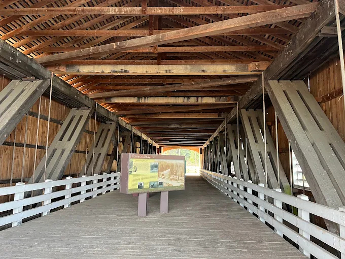
A covered wooden bridge has many virtues. Lots of overhead clearance for an upright dump-truck bed is not one of them.
The collision damaged roof bracing and portions of the entrance. Lane County repaired the bridge, and the modern bypass soon took over the job of carrying highway traffic. The covered bridge was ultimately closed to vehicles in 1981.
It was, in a way, the best thing that could have happened to it.
After more than seven decades of ferry crossings, trucks, logging traffic, reconstruction, reservoir construction and assorted vehicular abuse at this location, the old crossing could finally stop being a road.
The Bridge Gets a Second Life
Saving an old bridge is one thing. Giving people a reason to care about it is another.
Fortunately, Lowell’s story did not end with a locked gate and a weathering structure sitting beside a newer highway.
In 2006, the bridge was refurbished and reopened as a pedestrian attraction and interpretive center. Today visitors can walk onto the bridge and explore displays devoted to the history of the structure, covered-bridge engineering and the remarkable collection of covered bridges still scattered across Lane County.
It is a fitting second life.
Lane County has one of the richest collections of covered bridges anywhere in the western United States. The county says it has 20 covered bridges, 17 of which are listed on the National Register of Historic Places. Across Oregon, only about 50 historic covered bridges remain today, a fraction of the hundreds that once dotted the state.
In other words, the Lowell bridge is not some isolated curiosity.
It belongs to a much larger story about the way Oregonians once moved through a wet, timber-rich landscape.
Covered bridges survive especially well here because Oregon had the materials to build them and a climate that made covering wooden structures practical. The walls and roofs kept rain off critical timbers while openings provided light and ventilation. As construction materials and highway standards changed, steel and concrete gradually made the old wooden designs obsolete.
Most disappeared.
Some, like Lowell, survived long enough for people to begin seeing them as heritage instead of outdated infrastructure.
That shift in perspective may be the reason the bridge is still standing.
What It’s Like to Visit Today
For all its history, visiting the Lowell Covered Bridge is refreshingly uncomplicated.
The interpretive center is located just off Highway 58 near the intersection with Jasper-Lowell Road, making it an easy stop for anyone traveling between Eugene and the Cascade foothills. The official Eugene, Cascades & Coast visitor information describes the site as a Lane County park with parking, picnic facilities, restrooms and lake views. No recreation pass is required to visit.
You cannot drive a car through the historic bridge anymore, which is part of what makes the experience pleasant.
On foot, you have time to notice things that would otherwise blur past a windshield. Look at the timber framework overhead. Step toward the openings in the walls and watch Dexter Reservoir below. Notice just how close the water seems to the structure, especially after learning that the bridge was raised specifically to stay above the future lake.
And, of course, bring a camera.
The bridge is especially photogenic when Dexter Reservoir is calm enough to catch its reflection. In autumn, the surrounding vegetation begins shifting color against the deep greens of the foothills. Gray winter skies give the white bridge a moodier, almost old-Oregon quality, while summer brings blue water, green hills and travelers heading east toward Oakridge and the Cascades.
It is also one of those places that rewards a little patience.
Highway 58 traffic is close by, so this is not a remote wilderness destination. The magic comes from noticing the contrast. Modern cars and trucks rush through the corridor while an 80-year-old wooden bridge sits quietly beside them, preserved from a transportation system that disappeared generations ago.
That juxtaposition is part of Lowell’s charm.
The site also works nicely as the beginning of a larger covered-bridge outing.
Several historic bridges are clustered around Lowell, Dexter and Fall Creek, including the Pengra, Unity and Parvin covered bridges. Lane County’s concentration of these structures makes it possible to spend an afternoon wandering rural roads and seeing several very different examples without driving halfway across Oregon.
The Pengra Covered Bridge, for example, crosses Fall Creek and includes exceptionally long timbers in its truss. Unity dates to 1936 and still retains the feel of a rural working bridge. Parvin, farther along the back roads, sits over Lost Creek in a landscape that feels worlds removed from Eugene despite being relatively close to town.
For history lovers, photographers or anyone who enjoys Oregon’s quieter roadside places, Lowell makes a natural centerpiece for that trip.
More Than a Pretty Oregon Landmark
Covered bridges are easy to romanticize.
We see weathered wood, dark entrances, rivers below and forests beyond, and our minds immediately fill in the rest. Horse-drawn wagons. Muddy country roads. Farmers heading home. Maybe a little fog drifting between the fir trees for good measure.
There is nothing wrong with enjoying that nostalgia.
But Lowell is interesting precisely because its real story is messier.
The bridge exists because people needed to get across a river. Its predecessor was built because a ferry was no longer enough. The current structure exists because a truck damaged the old bridge. Then a dam project threatened to put the replacement too close to the water, so workers lifted it six feet. Years later, another truck damaged this bridge. Highway traffic eventually outgrew it, so engineers built a modern crossing beside it.
Every generation changed the landscape around the bridge according to what it needed at the time.
And somehow, instead of being demolished when its practical usefulness ended, Lowell was allowed to remain.
That is what makes preservation meaningful.
Historic places do not have to be grand mansions, famous battlefields or ornate government buildings. Sometimes history is a wooden bridge beside an Oregon highway.
The timbers overhead tell a story about the materials early bridge builders had available. The broad roadway speaks to the trucks and commerce that once moved through it. The water just beneath the floor reveals how dramatically federal dam construction changed the valley. The concrete bridge nearby shows why the old structure was eventually retired.
You can almost read the last century of transportation history without leaving the site.
A Bridge That Has Watched Oregon Change Around It
There are places around Oregon where history feels removed from everyday life, safely stored behind glass or explained on a plaque.
Lowell is different.
Here, history is still standing where it happened.
The bridge remains beside the water, not far from the highway that replaced its old role. Dexter Reservoir laps beneath a structure built before the reservoir existed. People walk through a roadway that once carried logging trucks and commuters. The community of Lowell still sits nearby, looking toward a landscape transformed by dams, highways, timber and time.
And the bridge continues to do what Oregon’s best historic places do.
It makes you look twice.
The first time, you see a beautiful white covered bridge.
The second time, you begin noticing everything around it.
The lake should not originally have been there. The bridge once sat lower. Cars once drove through those portals. Another bridge occupied the site before this one. Before that, people crossed the river by ferry.
Suddenly the quiet little roadside landmark becomes a timeline.
More than a century of change is compressed into one small corner of Lane County.
For travelers racing east toward the mountains, the Lowell Covered Bridge may only be a brief flash of white beside Highway 58. But for anyone willing to pull off the road and spend a little time there, it offers something increasingly rare.
Not a recreation of old Oregon.
A surviving piece of it.
Sources
- National Park Service, Lowell Bridge National Register of Historic Places documentation
- Lane County Public Works, Historic Covered Bridges in Lane County
- Eugene, Cascades & Oregon Coast, Lowell Covered Bridge Interpretive Center
- Travel Oregon, Lowell Bridge
- Oregon Department of Transportation, Historic Highway Bridges of Oregon
- U.S. Army Corps of Engineers, Dexter Dam
- City of Lowell, Community History