Planning details reviewed September 9, 2026. Portland is one of the rare cities where you can start the morning under a cathedral of firs, eat lunch beside a waterfall, and still be back downtown for dinner. The best hikes near Portland, Oregon range from creekside city trails to Columbia River Gorge viewpoints and easy Mount Hood lake loops.
This guide favors trails that deliver a memorable payoff without turning the drive into the entire day. The distances below describe the featured route—not every possible extension—and drive times are rough estimates from downtown Portland without heavy traffic. Conditions, fees, permits and closures can change quickly, so use the official planning links before you leave.
Want to explore beyond the metro area? Start with our statewide Oregon hiking map and planning guide. If waterfalls are the priority, compare every region in our Oregon waterfalls map or jump straight to our guide to waterfalls near Portland.
Best hikes near Portland at a glance
- Best city hike: Lower Macleay Trail to Pittock Mansion
- Best easy waterfall hike: Bridal Veil Falls
- Best waterfall loop: Latourell Falls Loop
- Best workout: Angel’s Rest
- Best Mount Hood view: Trillium Lake Loop
- Best rainy-day forest: Tryon Creek
- Best spring wildflowers: Camassia Natural Area
Compare 12 Portland-area hikes
“Easy” refers to the featured mileage and typical trail grade, not guaranteed conditions. Mud, ice, heat, wind, crowding and trail damage can make a short hike much harder.
| Hike | Featured route | Difficulty | Typical drive | Best for |
|---|---|---|---|---|
| Lower Macleay to Pittock Mansion | About 5 miles round trip | Moderate | 10 minutes | City forest and skyline views |
| Powell Butte | Choose a 3–4 mile loop | Easy to moderate | 25 minutes | Open views and flexible mileage |
| Tryon Creek | 2-mile loop | Easy to moderate | 15 minutes | Year-round forest |
| Mount Talbert | Choose a 2–4 mile loop | Moderate | 20 minutes | Short, steep workout |
| Camassia Natural Area | 0.6-mile main loop | Easy, uneven | 25 minutes | April and May wildflowers |
| Latourell Falls Loop | About 2 miles | Moderate | 35 minutes | Two waterfalls |
| Bridal Veil Falls | 0.6 mile round trip to falls | Easy to moderate | 35 minutes | Families and a quick stop |
| Wahclella Falls | About 2 miles round trip | Moderate | 45 minutes | Mossy canyon scenery |
| Angel’s Rest | About 4.8 miles round trip | Hard | 35 minutes | Big Gorge views |
| Multnomah–Wahkeena Loop | 5.2-mile loop | Hard | 40 minutes | A full waterfall circuit |
| Mirror Lake | About 4.3 miles including lake loop | Moderate | 65 minutes | Mountain lake scenery |
| Trillium Lake | 1.9-mile loop | Easy | 75 minutes | Families and Mount Hood photos |
The 12 best hikes near Portland, Oregon
1. Lower Macleay Trail to Pittock Mansion
About 5 miles round trip · Moderate · Northwest Portland
This is the Portland hike to choose when you want a real forest climb without leaving the city. From Lower Macleay Park, the route follows Balch Creek, joins the Wildwood Trail and climbs toward Pittock Mansion. The payoff is a broad city view with Mount Hood appearing on clear days.
The full out-and-back gains roughly 1,000 feet and feels more substantial than its urban location suggests. For a shorter outing, walk the first paved portion beside Balch Creek or turn around after reaching the Wildwood Trail. Parking at the Lower Macleay trailhead is limited, but TriMet routes also serve the area. Dogs must remain leashed.
Check the official Lower Macleay trail profile.
2. Powell Butte Nature Park
Choose a 3–4 mile loop · Easy to moderate · East Portland
Powell Butte is the most flexible entry on this list. Its network crosses open meadow and forest on an extinct cinder cone, so you can build a gentle walk or add rolling climbs. On a clear day, the summit area can reveal several Cascade peaks.
This is also a practical choice for mixed-ability groups because the park offers multiple route lengths and an accessible restroom near the visitor center. Some paths are shared with bikes or horses, and dogs must be leashed. The vehicle gate follows seasonal hours and closes promptly, so do not plan a last-minute return to the parking lot.
Check Powell Butte hours and the official trail map.
3. Tryon Creek State Natural Area
2-mile loop · Easy to moderate · Southwest Portland
For hiking near Portland when rain is in the forecast, Tryon Creek is hard to beat. Eight miles of intersecting trails wind through second-growth forest, cross wooden bridges and drop toward the creek. The official two-mile loop combining Old Main, Red Fox, Cedar, Middle Creek and Maple Ridge is a satisfying introduction.
Expect mud during wet weather. The 0.3-mile paved Trillium Trail is the park’s easiest option for visitors who want a shorter, more accessible forest experience. Dogs are allowed on leash. Oregon State Parks lists this as a day-use fee site, so confirm the current permit requirement before arriving.
Check Tryon Creek conditions, hours and maps.
4. Mount Talbert Nature Park
Choose a 2–4 mile loop · Moderate · Clackamas
Mount Talbert packs more than four miles of trails into a forested volcanic butte beside the city. Combine the park’s natural-surface paths for a short loop with enough climbing to raise your heart rate, then watch for oak woodland, spring wildflowers and migrating birds.
Some grades are steep and the summit is wooded, so come for the forest workout rather than a wide-open mountain panorama. Parking is free at the main Mather Road entrance, where restrooms and water are available. Pets and bikes are not allowed in the nature park.
Check Mount Talbert’s official visitor information.
5. Camassia Natural Area
0.6-mile main loop · Easy mileage, uneven tread · West Linn
Camassia is a small preserve with an outsized spring display. Its one-way main loop crosses a rocky plateau, oak woodland, vernal pools and meadows colored by camas and other native flowers. April and May are usually the headline months, but bloom timing changes with weather.
Short does not mean fully accessible: the route mixes narrow boardwalk, bare ground, wood chips, rocks and a few stairs. Spring mud and slippery boards are common, and poison oak grows in the preserve. Stay on the marked trail and leave dogs, bikes and drones at home; this privately protected landscape has stricter rules than a city park.
Read the preserve rules and current visitor guidance.
6. Latourell Falls Loop
About 2 miles · Moderate · Columbia River Gorge
Latourell delivers two distinctly different waterfalls on one compact loop. The lower falls plunge over a wall of columnar basalt streaked with bright lichen; the trail then climbs through forest to the two-tiered Upper Latourell Falls before returning along the opposite side of the creek.
Rocky tread, stairs and several small bridges make this more involved than the mileage suggests. The route also crosses the Historic Columbia River Highway, so use the designated crossing carefully. Oregon State Parks added the Latourell trailhead to its day-use fee program in 2026; verify the current fee and any notices before the drive.
Use our complete Latourell Falls guide and Upper Latourell Falls guide to plan the stop. Check the official park profile.
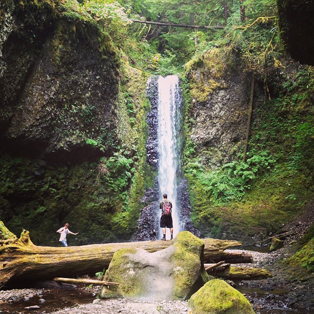
Econa Falls along the Multnomah–Wahkeena Loop. Photo by Greg Younger via Flickr.
7. Bridal Veil Falls
0.6 mile round trip to the falls · Easy to moderate · Columbia River Gorge
Bridal Veil is one of the best easy hikes near Portland when you want a waterfall without committing half a day. The lower trail descends about 0.3 mile to a two-tiered cascade framed by mossy basalt. The return climb is short but steep enough to feel like a hike.
Add the separate half-mile Overlook Trail for Columbia River views and interpretive signs. Do not walk onto the narrow Historic Highway bridge to look for the falls; Oregon State Parks directs visitors to view it from the trail. The site joined the state day-use fee program in 2026, so check the current requirement.
See our Bridal Veil Falls planning guide and official park profile.
8. Wahclella Falls
About 2 miles round trip · Moderate · Columbia River Gorge
Wahclella Falls follows Tanner Creek into a narrow, green canyon. The trail passes small Munra Falls near the beginning and continues over bridges toward the amphitheater around the main cascade. It is one of the strongest scenery-per-mile choices in the Gorge.
Parts of the path are narrow and exposed above the creek. Rockfall, storm damage and wildfire recovery can also affect access, so this is not a trail to plan from an old screenshot. Check current Forest Service alerts on the morning of your hike and keep children close around drop-offs. A federal recreation pass or site fee may be required.
Start with our Wahclella Falls guide, then confirm conditions with the Columbia River Gorge National Scenic Area.
9. Angel’s Rest
About 4.8 miles round trip · Hard · Columbia River Gorge
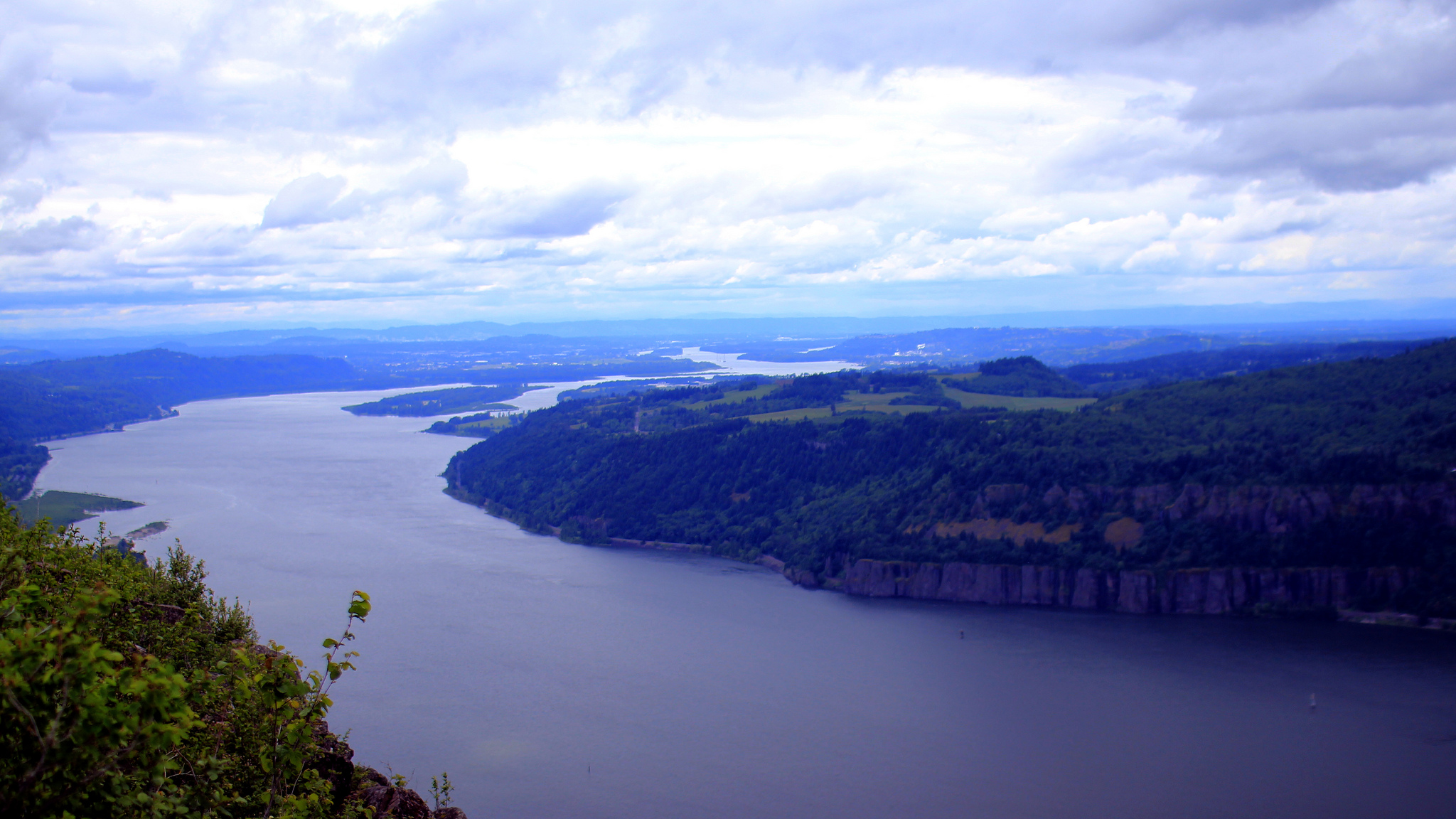
View from Angel’s Rest. Photo by Bill Automata via Flickr.
Angel’s Rest is the classic short-but-steep Portland-area workout. The climb gains roughly 1,500 feet before reaching an exposed rocky viewpoint over the Columbia River Gorge. It is a rewarding choice for hikers who want elevation and a panorama rather than an easy family stroll.
The summit area has unguarded drop-offs, while summer heat and winter ice can turn the route serious. Carry water, keep children and dogs under direct control, and turn around if the wind or footing feels unsafe. Angel’s Rest became an Oregon State Parks day-use fee site in 2026; confirm the current parking requirement and trail notices.
Check Oregon State Parks notices and Forest Service Gorge alerts before leaving.
10. Multnomah–Wahkeena Loop
5.2-mile loop · Hard · Columbia River Gorge
This is the high-payoff waterfall circuit near Portland: Multnomah Falls, Wahkeena Falls, Fairy Falls and several smaller cascades appear along a steep forest loop. Expect sustained climbing, stone steps, wet surfaces and busy trailheads—not a casual extension of the lodge viewpoint.
Parking access and seasonal timed-use programs around Multnomah Falls have changed repeatedly. Do not assume last year’s system still applies. Choose your legal starting point, carry a map, and check both trail closures and transportation requirements. If the full loop is too much, the paved lower viewpoint at Multnomah Falls or the short walk to Wahkeena Falls offers a much easier alternative.
Review our Multnomah Falls guide, then use Ready, Set, GOrge and the Forest Service for current access.
11. Mirror Lake
About 4.3 miles including the lake loop · Moderate · Mount Hood
Mirror Lake is one of the most popular short hikes near Portland for a close-up Mount Hood setting. From the current trailhead, the route climbs steadily to the lake; adding the path around the shore brings the outing to roughly 4.3 miles. Continue toward Tom Dick and Harry Mountain only if you are prepared for a much longer and harder hike.
The trail enters designated wilderness above the lake, and snow can linger well beyond Portland’s spring. Winter travel requires navigation and avalanche awareness, not just warm boots. Parking rules and pass requirements also change by season, so check Mount Hood National Forest guidance instead of relying on roadside parking habits from older trip reports.
Pair the hike with our Mount Hood travel guide and confirm current details with Mount Hood National Forest.
12. Trillium Lake Loop
1.9-mile loop · Easy · Mount Hood
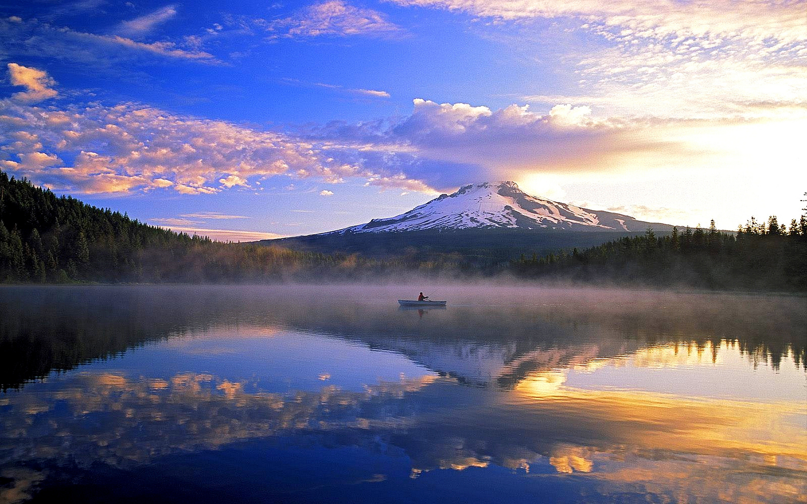
Trillium Lake with Mount Hood beyond. Photo by Mt. Hood Territory via Flickr.
Trillium Lake is the easiest Mount Hood hike in this guide. The mostly level loop uses compacted surface and boardwalk as it circles wetlands and opens to the postcard view across the water. It is popular with families, photographers and visitors combining a short walk with a scenic drive.
The access road and facilities are seasonal, and snow can transform the outing into a longer winter route from the sno-park. Summer parking fills quickly. Verify road status, recreation-pass requirements and wildfire restrictions before leaving Portland.
Check Mount Hood National Forest conditions and use our Mount Hood guide to build the rest of the day.
How to choose the right Portland hike
For an easy walk
Choose Trillium Lake, Camassia or the shorter options at Tryon Creek. Bridal Veil is brief, but remember that the return from the waterfall climbs uphill. “Easy” never cancels out wet roots, ice, heat or mobility needs.
For waterfalls
Latourell gives the best compact loop, Wahclella delivers the strongest canyon atmosphere, and Multnomah–Wahkeena offers the biggest full-day workout. Bridal Veil is the simplest choice for families or a quick Historic Highway stop.
For a hike without a long drive
Lower Macleay, Tryon Creek and Powell Butte are the strongest Portland hikes inside city limits. Mount Talbert and Camassia add nearby suburban options without committing to Gorge or Mount Hood traffic.
For views
Angel’s Rest is the dramatic Gorge choice. Pittock Mansion pairs forest with the Portland skyline, Powell Butte offers open Cascade views in clear weather, and Trillium Lake frames Mount Hood across the water.
Before you go
- Check the land manager, not an old social post. Confirm closures, fire restrictions, road access, parking rules and permits on the day of your trip.
- Carry two backup hikes. Gorge and Mount Hood parking can fill early, especially on sunny weekends.
- Do not leave valuables visible. Trailhead theft happens in both city parks and remote recreation areas.
- Pack the ten essentials. A short route can still become an emergency when weather changes or an injury slows the return.
- Respect pet rules. Leash requirements vary, and Mount Talbert and Camassia do not allow pets.
- Stay on official trails. Do not follow informal shortcuts, scramble around barriers or park on vegetation.
- Leave a trip plan. Tell someone where you are going and when to expect you back.
Frequently asked questions
What are the best hikes near Portland for first-time visitors?
Latourell Falls, Lower Macleay to Pittock Mansion and Trillium Lake show three very different sides of the region: the Columbia River Gorge, Portland’s urban forest and Mount Hood. Choose one based on weather and how much driving you want.
What are the easiest hikes near Portland?
The Trillium Trail at Tryon Creek, Camassia’s main loop, Bridal Veil Falls and Trillium Lake are among the shortest options in this guide. Trail surface and weather still matter, so read the accessibility and condition notes rather than choosing by mileage alone.
Which hikes near Portland have waterfalls?
Latourell Falls, Bridal Veil Falls, Wahclella Falls and the Multnomah–Wahkeena Loop are the strongest waterfall hikes in this list. Our waterfalls near Portland guide includes more choices.
Can I hike near Portland without a car?
Lower Macleay is the clearest option here because several TriMet routes serve the trailhead area. Portland’s larger trail network also includes transit-accessible entrances to Forest Park, Washington Park and other natural areas; verify the current bus route before leaving.
When is the best time to hike near Portland?
City and lower-elevation forest trails can work year-round. Spring is best for waterfalls and wildflowers, summer opens higher Mount Hood routes, and fall brings cooler temperatures and changing leaves. Winter adds mud, ice, snow and shorter daylight, so route choice matters more than the calendar.
Do hikes near Portland require permits or parking fees?
Some do. Oregon State Parks expanded its day-use fee program in 2026, several federal trailheads require a recreation pass, and seasonal timed-use systems can affect the Multnomah Falls corridor. Requirements change, so follow each official link above before driving.
Looking farther south for a full waterfall day? Our updated Silver Falls State Park and Trail of Ten Falls guide covers the longer drive, route options and current planning details.