Summer skiing is part of Mount Hood’s identity. This fall, exposed rock spread across the Palmer slope above Timberline Lodge, leaving much of the familiar white expanse gray. A photo shared by KGW meteorologist Rod Hill on October 7 brought the change into view.
The slope received a thin coating of fresh snow by Saturday morning. Timberline’s Palmer/Silcox webcam showed white around the lift towers at 7:37 a.m. October 10, with rocks still visible through it. Underneath that new cover is a place that researchers had already watched change from an active glacier into seasonal snowfields.
Palmer’s earlier melt-out has consequences for summer recreation, while the mountain’s broader glacier decline affects water supplies below. The recent satellite comparison, decades of field observations and climbing rangers’ reports describe different parts of that change.
Where the snow went
Palmer sits on Mount Hood’s south side, above Timberline Lodge. It is the slope generations of skiers associate with summer turns and climbers cross on their way toward the upper mountain. Its lift towers make the change particularly easy to see: this fall, much of the familiar white ski slope became a slope of gray rock.
Mount Hood still has snow and ice elsewhere. Palmer is one part of the mountain, and a photograph from Timberline cannot show what remains on every glacier, in shaded gullies or beneath rock debris. “The Palmer is nearly bare” describes a specific place. Calling the whole mountain snow-free would go well beyond the available evidence.
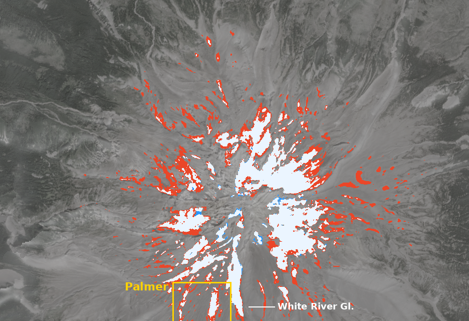
A satellite analysis published by HikeIt on October 8 estimated 96 acres of surface snow and ice in its Palmer study area on August 24, 2025, compared with 29 acres on August 24, 2026, a decline of about 70 percent. On October 3, it detected none on the lower Palmer and about five acres across the full study area. The lower slope was almost bare roughly five weeks earlier than in 2025.
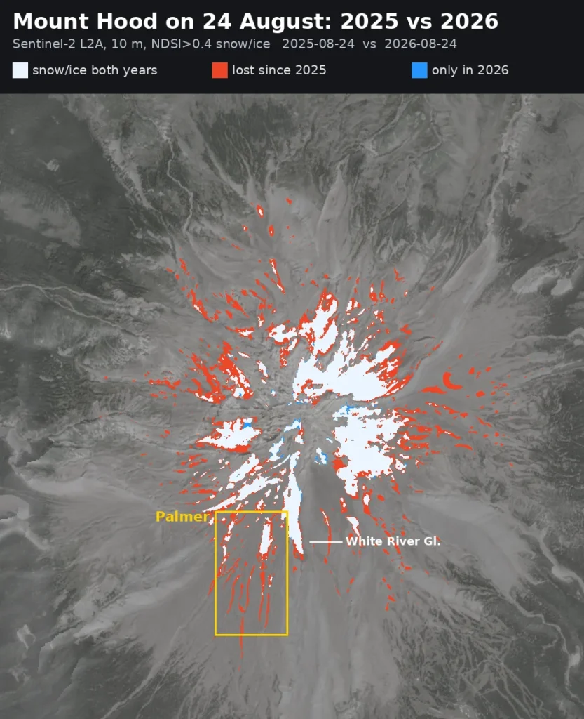
These are estimates of visible surface coverage, not measurements of glacier thickness or total ice volume. Clouds and small or debris-covered patches limit what the satellite analysis detects. Its October 3 estimate predates this weekend’s snow. It should not be presented as a live count for October 10.
Palmer stopped being an active glacier years ago
The name can be confusing. Older maps and longtime Oregonians call it Palmer Glacier. Skiers generally know it as the Palmer Snowfield. Both names have a history, but they describe different stages of the same place.
A glacier consists of ice that moves under its own weight. A snowfield can cover the ground without that flow. A glacier can also leave stagnant ice behind after it stops moving, sometimes hidden beneath loose rock. Losing the white surface does not necessarily mean every piece of older ice underneath has disappeared.
The field notes accompanying a 2024 glacier study trace Palmer’s change over decades. Researchers say it was first identified as a glacier in 1924 and remained active in 1981, when its maximum thickness reached about 60 meters, or 197 feet. By their 2003 observations, it no longer showed evidence of active flow. Two perennial snowfields remained over stagnant ice.
By 2023, those snowfields had become seasonal, disappearing in late September or October despite Timberline’s efforts to collect and store snow for summer skiing. Once the seasonal cover melted, the researchers observed small remnants of stagnant ice beneath rock debris.
Hill’s October 7 post described this as Palmer’s first nearly snow-free autumn since Timberline opened. The earlier field observations document seasonal melt-outs by 2023, so the available research does not support that first-time claim. This autumn’s early loss comes after years of change.
Winter can cover the slope again. Rebuilding ice takes longer.
The U.S. Geological Survey describes the seasonal cycle: glaciers generally accumulate snow in winter and lose snow and ice during summer melting. Their long-term condition depends on how those gains and losses add up.
A snowy winter can cover Palmer and provide snow for skiing. To build lasting ice, some accumulation must survive the following melt season. Repeated years of loss reduce the older reserve even when the mountain looks white for much of the year.
That is why late-summer observations tell researchers something a midwinter photograph cannot. They show what remains after the annual melt. At Palmer, the field notes describe snowfields that once persisted through summer but had become seasonal by 2023.
For this coming winter, the October photographs establish neither an opening date nor a season-long skiing outlook. Those will depend on the snow and weather still ahead. The morning’s thin coating is the first change visitors can see, with months of accumulation and melting left to follow.
What the change means for summer skiing
A lift-served ski slope depends on usable snow where people actually ski. Snow surviving elsewhere on Mount Hood cannot replace coverage along Palmer’s lift and runs. That makes the location of the remaining snow as relevant to ski operations as the total acreage.
The glacier study’s field notes describe Timberline collecting and storing snow to help sustain summer skiing, even as Palmer’s snowfields became seasonal. Those efforts support a recreational surface; they do not, by themselves, demonstrate that the former glacier has resumed flowing.
A groomed strip and a shrinking snowfield can exist at the same time. Skiers are concerned with the snow available on a run; researchers examine the extent and persistence of snow and ice across a larger area. The satellite map measures surface coverage in its study boundary and does not establish how many days a particular run was skiable.
Anyone planning a ski trip should use Timberline’s current conditions report for operating information. Neither the August comparison nor October’s bare-slope photographs announce a closure or an opening.
Other Mount Hood glaciers are shrinking too
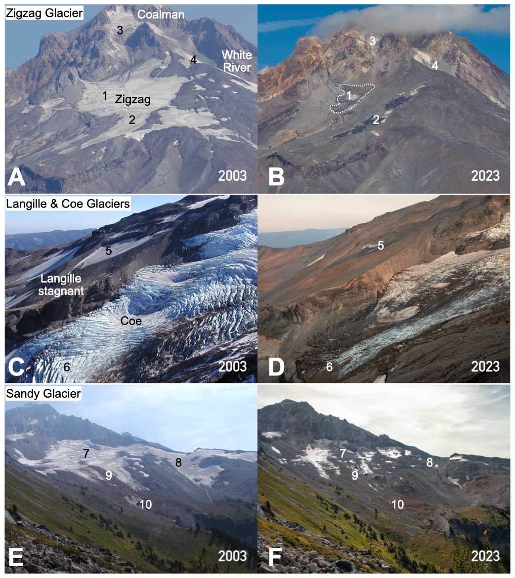
The 2024 study in The Cryosphere, led by Nicolas Bakken-French with Oregon Glaciers Institute researchers and colleagues, combined field observations, repeat photographs and remote sensing. It found Mount Hood’s glaciers had lost about 17 percent of their 2015–2016 area by 2023 and about 39 percent of their 1981 area. The rate of area loss from 2015–2016 to 2023 was about 2.6 times the rate from 1981 to 2015–2016.
Those figures describe glacier area across the study’s historical periods. They are different measurements from this autumn’s surface-snow estimates around Palmer. A 70 percent change in one snow-covered study area over one year does not mean Mount Hood lost 70 percent of its glacier ice.
The researchers attributed the mountain’s accelerating glacier retreat to a warming climate. Regional summer temperatures averaged about 1.7 to 1.8 degrees Celsius warmer in 2013–2023 than in 1895–1924. They found that changes in winter precipitation did not explain the recent retreat.
The photographs below cover two decades, rather than the recent melt-out at Palmer.
The water matters long after ski season
Snow and ice high on Mount Hood store water that feeds summer supplies below, including irrigation for Hood River Valley orchards.
The U.S. Geological Survey explains that meltwater from Mount Hood’s glaciers and seasonal snowpack supplies irrigation water for Hood River Valley orchards and helps maintain flows in fish habitat. The timing matters: late-summer melt arrives when seasonal snow has diminished and streams need water.
A photograph of Palmer alone cannot tell us how much water a particular orchard, irrigation district or stream will receive. That requires measurements across the relevant watershed. It does show why the amount of ice remaining after summer deserves attention alongside the amount of snow that falls in winter.
The seasonal snowpack and glacier ice provide water over different timescales. Snow accumulated during one winter can melt within the next season. Older ice stores water across years. Losing that reserve changes what remains available after the seasonal cover has dwindled.
Fresh snow has arrived. The summit warning remains
As checked Saturday morning, the Forest Service’s current early fall climbing statement was still the report issued September 8. Climbing rangers advise against summit attempts because of exposed rock, crevasses and poor upper-mountain travel conditions. They say many feet of snow are needed to improve alpine travel.
Rockfall remains a major hazard until loose rock is buried. Light snow can hide open cracks or form bridges too thin to support a person. With rocks and holes below a snow slope, a sliding fall can have severe consequences. A little new white on the mountain offers no assurance that a climbing route has become suitable.
The rangers also warn that storms can add rime ice and renewed icefall potential, particularly during a subsequent warm-up. Their September report says an earlier dusting did not substantially improve upper-mountain conditions. Check for a newer statement before making any climbing plans.
What to expect on the mountain this weekend
The National Weather Service upper-mountain forecast, updated at 6:41 a.m. October 10 for a point at 9,623 feet, called for a 30 percent chance of snow between 10 a.m. and noon Saturday, with less than half an inch of daytime accumulation possible. Temperatures were expected to fall to around 22 degrees by late morning, with gusts reaching 28 mph.
Sunday’s forecast at that elevation was mostly sunny, with a high near 27 degrees and gusts up to 31 mph. These are upper-mountain numbers, not temperatures for Government Camp or Timberline Lodge. Use the forecast for the elevation you plan to visit, and check it again before leaving.
The weekend can bring a wintry view without enough snowfall to fill crevasses or bury loose rock. Sunshine on Sunday would improve visibility; it would not, by itself, resolve those hazards.
You can visit Timberline without climbing Hood
A lodge visit gives you a chance to see the south side without committing to the upper mountain. Keep the day centered on the lodge and established visitor areas if that is the outing you came for. Walking uphill toward the lift towers is a different trip, especially in cold weather and poor visibility.
Timberline’s webcams provide a useful first look before the drive. Notice the timestamp and whether clouds obscure the slope. A clear image from earlier in the week should not override a newer forecast or a current climbing warning.
If you plan to walk uphill within the ski area, check Timberline’s uphill travel policy first. Its free uphill pass requirement includes foot travel from the ski-area parking lots, including the climbers’ trail. A pass does not establish that the terrain or weather is suitable for your trip.
The Forest Service separately requires a Mount Hood Climbing Permit for travel above 9,500 feet.
For a day around the mountain, our Mount Hood guide covers the broader visit. Check Oregon road conditions through TripCheck before driving Highway 26 or Timberline Road, and match your plans to the conditions you find.