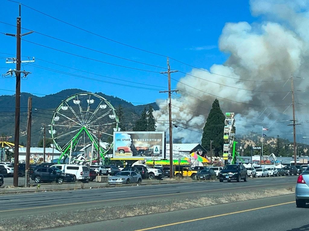
Firefighters working through the night have completed fireline around the entire perimeter of the wildfire that erupted beside Interstate 5 north of Grants Pass, an important step forward after the fast-moving blaze destroyed a home and threatened surrounding neighborhoods Saturday.
Updated infrared mapping now places the fire at approximately 96 acres. Officials stressed that the larger number does not mean the wildfire expanded significantly overnight. The revised acreage came from more precise mapping conducted by an infrared-equipped unmanned aircraft.
Roughly 125 firefighters and support personnel are assigned to the incident Sunday as crews continue strengthening the perimeter, extinguishing lingering heat and preparing for another afternoon of potentially gusty winds.
The fire began Saturday near the northbound lanes of Interstate 5 at milepost 57, approximately five miles east of Grants Pass. What first appeared to be a relatively small roadside grass fire quickly climbed into dry brush and steep terrain, triggering a large response from the Oregon Department of Forestry Southwest Oregon District and numerous partner agencies.
By Sunday morning, the most urgent phase of the battle had eased, but firefighters still faced a long day of difficult work.
Fireline Completed Around the Entire Perimeter
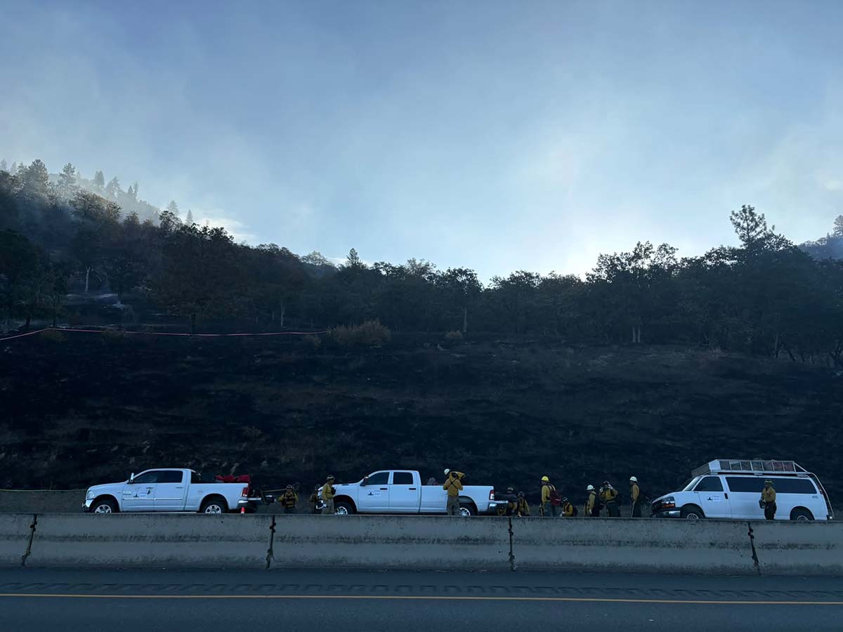
Crews spent Saturday night improving and reinforcing the lines constructed during the initial attack.
Fireline has now been completed around the entire wildfire perimeter. That means firefighters have created a continuous break intended to separate the burned area from unburned vegetation.
It is an encouraging development, but it does not necessarily mean the fire is officially 100 percent contained. Fire managers must determine that the lines are secure enough to hold under changing conditions before raising the official containment figure.
Sunday’s primary objective is to keep the wildfire within the footprint established Saturday while firefighters continue putting out hotspots and increasing the depth of mop-up around the perimeter.
Crews have already completed approximately 10 feet of mop-up along the fire’s northern flank. That work involves searching the ground immediately inside the fireline for burning roots, smoldering vegetation and other heat sources capable of reigniting.
Progress has been slower along the southern flank, where firefighters are moving through thicker vegetation and heavier fuels.
Dense brush, logs and root systems can continue holding heat long after visible flames disappear. Crews must carefully locate and extinguish those pockets before the fireline can be considered secure.
The official That Oregon Life store
The Oregon you bring home.
Start the day with Oregon-roasted coffee, then find original gear inspired by the places, stories, and oddities that make this state ours.
Shop Oregon gear


Infrared Drone Produces More Accurate Map
An unmanned aircraft equipped with infrared technology flew over the fire during the night, allowing managers to see through smoke and identify heat that may not have been visible from the ground.
The flight also produced a more detailed map of the wildfire.
Previous estimates placed the fire between 75 and 80 acres. Infrared data now shows the actual footprint is closer to 96 acres.
Officials said the increase reflects improved mapping rather than substantial overnight growth.
Early wildfire acreage estimates are often made while smoke is obscuring the landscape and firefighters are still actively trying to stop the flames. Rugged terrain can make those estimates especially difficult.
Infrared sensors provide a much clearer picture by detecting heat across the landscape and tracing the outer edge of the burned area.
That information will also help crews determine where the most persistent hotspots remain.
About 125 Personnel Assigned Sunday
Approximately 125 personnel are working the incident Sunday.
Resources include five hand crews with about 20 firefighters each, five Type 6 wildland engines, five water tenders and five bulldozers.
Type 6 engines are smaller and more maneuverable than municipal fire engines, allowing firefighters to reach rough roads and areas where larger vehicles may struggle to operate.
Water tenders keep those engines supplied in places where fire hydrants are unavailable, while bulldozers construct and reinforce wider sections of fireline.
Firefighters are once again working on steep hillsides, adding another level of difficulty and danger to the operation.
Loose rocks, uneven ground and fire-damaged trees can make movement hazardous. Crews must also carry tools and equipment while climbing through areas blackened by the fire.
Helicopters Remain Ready Above the Fire
Aircraft played a major role in slowing the wildfire Saturday as flames moved across the hillside.
The initial response included helicopters, Large Air Tankers, a Very Large Air Tanker and military-supported Modular Airborne FireFighting System aircraft.
Air tankers dropped retardant ahead of the flames to slow their advance, while helicopters delivered water to active sections of the fire.
A Type 1 helicopter and a Type 2 helicopter are assigned to the incident Sunday. Additional aircraft are available if fire behavior increases or crews need more support.
Type 1 helicopters are the largest category commonly used in wildfire operations and can carry substantial quantities of water. Type 2 helicopters are smaller but remain valuable for water drops, transporting personnel and supporting crews in difficult terrain.
A Temporary Flight Restriction remains in effect over the fire area.
Officials are again asking members of the public not to fly recreational drones anywhere near the wildfire. An unauthorized drone entering restricted airspace can force firefighting aircraft to land, interrupting suppression efforts and creating a serious collision hazard.
Gusty Winds Could Produce Spot Fires
Conditions are expected to be slightly cooler Sunday than they were when the wildfire began, but afternoon winds remain a concern.
Gusts can lift burning embers and carry them beyond the established fireline. Those embers can ignite small spot fires in dry grass, brush or timber.
Spot fires are not unusual during windy wildfire conditions, particularly in Southern Oregon during August. Crews are positioned to respond aggressively if any new ignitions appear outside the perimeter.
Keeping the fire within its existing footprint will be the central focus of Sunday’s operation.
The completed line gives firefighters a strong defensive position, but it must continue holding as temperatures rise, humidity drops and winds move across the hillside.
One Home Destroyed During Initial Fire Run
One residence was destroyed during the early stages of the wildfire Saturday.
No additional structure losses were reported as firefighters gained ground during the afternoon and evening.
Protecting nearby homes remained a major priority throughout the incident. Engines and structure-protection crews worked near threatened properties while wildland firefighters attacked the flames across the hillside.
The speed of the response likely prevented the fire from becoming much more destructive.
Southern Oregon’s hillsides can become extremely receptive to fire by late summer. Dry grass provides an easy path for flames, while thicker brush and timber can produce more intense heat once a fire moves beyond the roadside.
A seemingly routine grass fire can become a dangerous wildfire in a matter of minutes under those conditions.
Northbound I-5 Reduced to One Lane
Northbound Interstate 5 has been reduced to one lane as traffic passes the fire area.
Drivers should expect delays, slow down and remain alert for emergency vehicles and personnel working near the highway.
TripCheck listed a fire-related hazard affecting the northbound lanes near mileposts 55 to 57 Sunday morning, with travelers advised to prepare for delays while passing through the area.
Anyone planning to travel through Grants Pass should check current highway conditions before leaving.
Drivers should also avoid stopping along the interstate to photograph the fire. Slowing unexpectedly or pulling onto the shoulder can create additional hazards for firefighters and passing traffic.
Firefighters Still Have Work Ahead
Completing fireline around the entire 96-acre perimeter represents significant progress after an intense first day.
The wildfire is no longer displaying the widespread aggressive behavior seen Saturday afternoon, but crews will remain focused on hotspots, hazardous trees and areas where heavier fuels continue smoldering.
Mop-up can take time, particularly on steep ground where heat may be hidden beneath roots, logs and dense vegetation.
Firefighters will continue widening and reinforcing the protected area inside the fireline while watching for smoke or new flames outside the perimeter.
An evening update is expected to provide the latest information on containment, fire activity and Sunday’s progress.
For residents of Southern Oregon, the fire is another reminder of how quickly conditions can change during the height of wildfire season.
What began beside Oregon’s busiest north-south highway rapidly became a major incident involving aircraft, bulldozers, engines and more than a hundred firefighters.
The danger is not completely over, but Sunday morning’s update brought welcome news. The fire remained within its mapped footprint overnight, crews completed line around the entire perimeter, and firefighters entered the day in a much stronger position than they had just hours earlier.
Source: Oregon Department of Forestry Southwest Oregon District.
For current Oregon fire conditions: Track current fire incidents, mapped evacuation areas, smoke, road conditions, and official resources on our Oregon Wildfire Map.