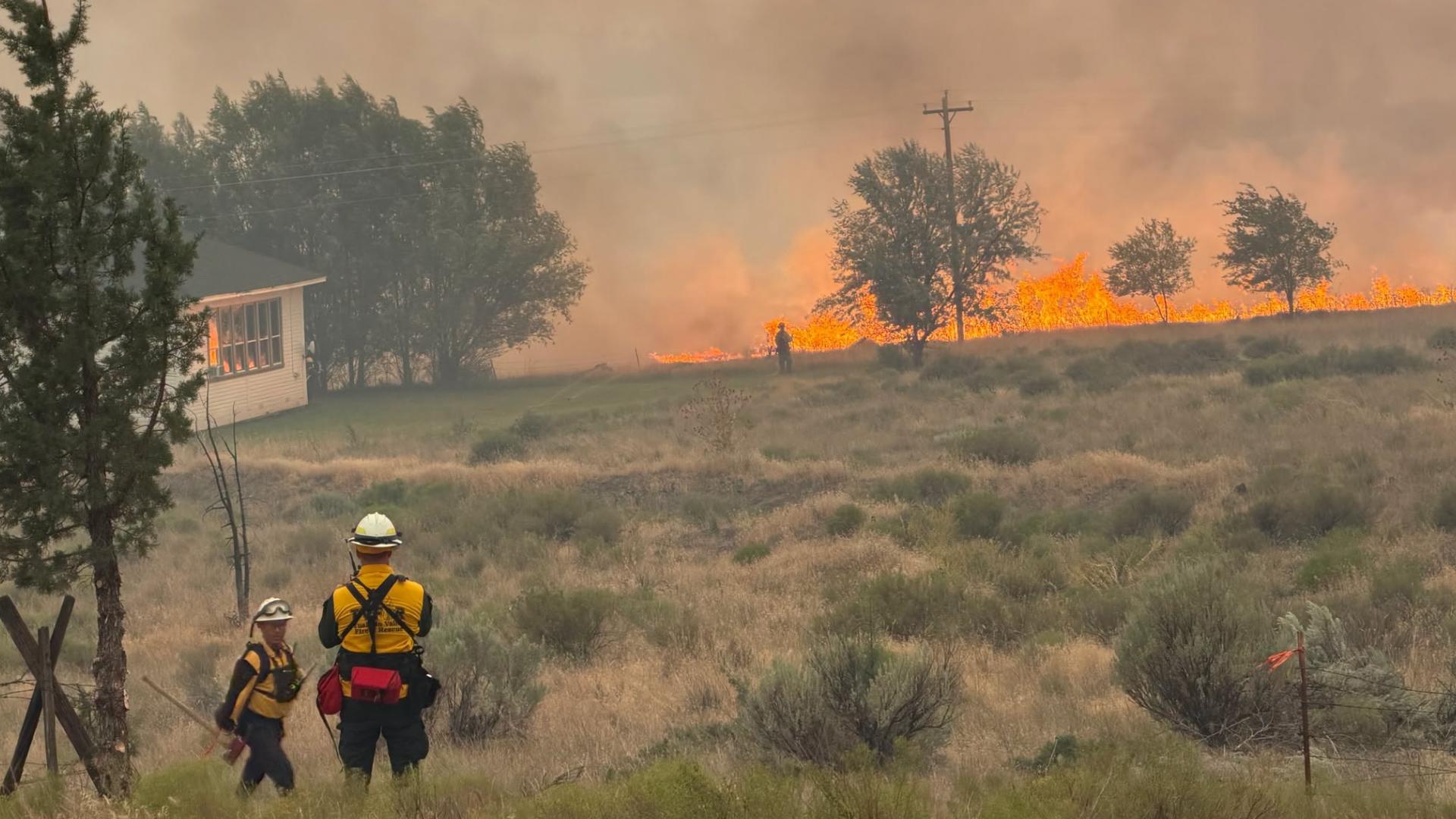
Oregon’s wildfire season has taken a sudden and dangerous turn.
After a relatively mild beginning to summer, a punishing combination of dry vegetation, thunderstorms, lightning, and strong winds has ignited or rapidly expanded fires across several regions of the state. From the rolling wheat country near Arlington to the forests of Southern Oregon and the rugged canyons surrounding the John Day River, firefighters are now confronting dozens of active incidents.
Several communities remain under Level 1, Level 2, or Level 3 evacuation notices, while highways, national forest lands, recreation areas, and portions of John Day Fossil Beds National Monument have been closed.
Wildfires in Central Oregon bring smoke, unhealthy air to Boise area https://t.co/LwAKOm8OuW
— Idaho Statesman (@IdahoStatesman) July 18, 2026
The fire locations, acreage estimates, containment figures, and evacuation boundaries below were current as of the evening of July 18, 2026. Conditions can change quickly, sometimes before a public news release is issued.
Residents near an active fire should rely on their county sheriff’s office and official interactive evacuation maps for the most current information. Oregon’s RAPTOR map, Genasys Protect, Everbridge, county ArcGIS maps, and local emergency alert systems can show whether a particular road, neighborhood, or property is inside an evacuation zone.
The Oregon State Fire Marshal also maintains a statewide wildfire map, while the Oregon Department of Forestry provides links to current large-fire information and incident resources.
Oregon Mobilizes Additional Firefighting Resources
Governor Tina Kotek issued a preemptive emergency declaration on June 16, allowing Oregon fire agencies to move personnel and equipment between jurisdictions more easily as conditions worsened.
Emergency conflagration declarations have since been issued for multiple incidents. These declarations allow the Oregon State Fire Marshal to mobilize structural firefighters, engines, task forces, and other resources from around the state when local capabilities are stretched.
As the number of fires rises, Oregon crews are being asked to defend homes and communities while also protecting highways, power infrastructure, forests, recreation destinations, and working agricultural land.
Gilliam County Fires Threaten Areas Near Arlington and Condon
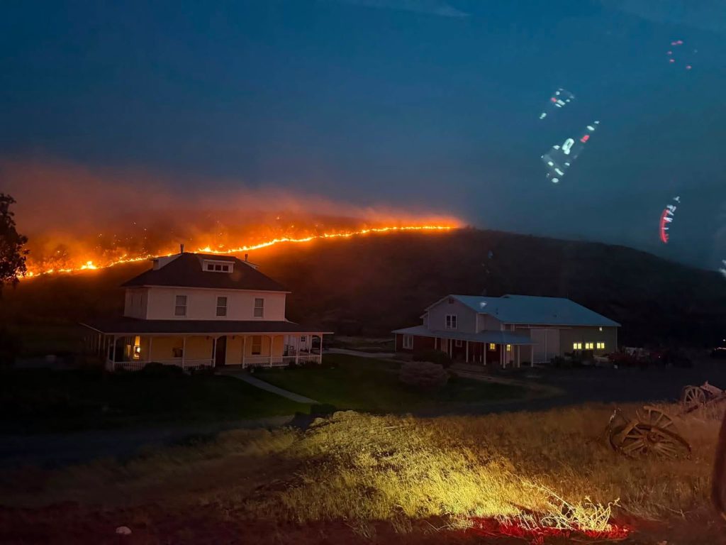
Some of the most intense fire activity is occurring in Gilliam County, where several fires are burning near Arlington, Condon, and Highway 74.
Hoag/Lower Rock Creek Fire
The Hoag/Lower Rock Creek Fire began July 16 south of Arlington near the Rock Creek area. It had grown to approximately 10,000 acres with no containment reported.
Level 1, Level 2, and Level 3 evacuation zones were established southwest and southeast of Arlington.
Residents should use Oregon’s RAPTOR evacuation map to view the latest mapped boundaries. Those boundaries may shift as winds change, crews establish fire lines, or new areas become threatened.
Arlington Elementary School has been made available as a shelter for displaced residents.
For current evacuation notices, shelter information, and local fire updates, visit the Gilliam County Sheriff’s Office.
Hopkins Fire
The Hopkins Fire ignited July 15 north of Condon and has burned roughly 4,000 acres.
While much of the fire’s growth has stayed away from populated areas, evacuation orders were issued for portions of Scott Canyon Lane. Travelers should also be aware that restrictions may be in place along Highway 19 near Gwendolen.
A temporary shelter has been established at the South Gilliam Emergency Services Building in Condon.
For the latest evacuation information, road updates, and fire conditions, visit the Gilliam County Sheriff’s Office.
Porcupine Ridge Fire
The Porcupine Ridge Fire, burning about seven miles southwest of Condon, had grown to approximately 15,620 acres.
The cause had not been officially confirmed, though lightning was believed to be the likely source.
Level 3 evacuation orders were issued for the airbase area off Richmond Lane. A temporary shelter is available at the South Gilliam Emergency Services Building, located at 220 Northeast Main Street in Condon.
For the latest evacuation notices, shelter updates, and fire information, visit the Gilliam County Sheriff’s Office.
Sully Fire
The Sully Fire was reported July 18 near Highway 74 at milepost 3.
Its acreage had not yet been confirmed, and investigators were still working to determine the cause. Officials indicated that electrical transmission equipment may have been involved.
Level 2 evacuation notices were issued for residents along Sullivan Lane and south toward Rhea Lane.
Gilliam County residents should continue checking the sheriff’s office and RAPTOR map rather than relying only on older social media posts or screenshots, since evacuation zones may be revised throughout the day.
For the latest evacuation information, road updates, and fire conditions, visit the Gilliam County Sheriff’s Office.
Lightning Fires Continue Burning Near Granite and Baker City
Several fires burning across Grant and Baker counties were sparked by lightning on July 8.
The remote terrain surrounding the North Fork John Day Wilderness has made access difficult, while the fires have threatened communities, cabins, recreation areas, and forestland.
Salmon Fire
The Salmon Fire, southwest of Granite, had burned approximately 1,492 acres and was about 15% contained.
Olive Butte Fire
The nearby Olive Butte Fire had reached approximately 2,652 acres with about 10% containment.
Anthony Fire
The Anthony Fire, burning about 34 miles north of Baker City, had grown to approximately 1,948 acres and was 8% contained.
Level 1, Level 2, and Level 3 evacuation notices remained in place around the Salmon, Olive Butte, and Anthony fires, with the Baker County Sheriff’s Office coordinating local evacuation updates.
Temporary closures were also in effect across portions of the Malheur, Umatilla, and Wallowa-Whitman national forests.
Firefighting progress allowed officials to reduce Granite’s evacuation status from Level 3 to Level 2, though residents in the surrounding area were still being advised to remain ready to leave if conditions changed.
For the latest evacuation information, visit the Baker County Sheriff’s Office. Travelers planning to camp, hike, hunt, fish, or drive through northeastern Oregon should also review the official forest closure maps before heading out.
East Evans Creek Fire Burns More Than 11,000 Acres
The East Evans Creek Fire is burning about 14 miles northeast of Rogue River in Jackson County.
The human-caused fire began July 10 and had grown to approximately 11,551 acres, with containment reported at 5%.
Level 1, Level 2, and Level 3 evacuation notices were active in Jackson County, while some Level 1 areas extended into Douglas County.
Firefighters have been dealing with challenging conditions along the perimeter, including spot fires that crossed established lines. Crews continued working to secure those areas while protecting structures and mopping up hot spots.
Several roads were closed or restricted, including:
- Tiller-Trail Highway from the Jackson County line to Highway 62
- East Evans Creek Road at Meadows Road
- West Fork Evans Creek Road
- Rock Creek Road
For the latest acreage, containment, and firefighting updates, visit the East Evans Creek Fire page on InciWeb.
Residents should also check the official interactive evacuation map before traveling near the fire area, since road closures and evacuation boundaries can change quickly.mpting to enter the area. A road that appears open early in the day may close quickly if fire activity increases.
Fires Near Lake Billy Chinook Affect Jefferson, Deschutes, and Crook Counties
Two fires in Central Oregon had each grown to approximately 5,000 acres by July 18.
Akawa Butte Fire
The Akawa Butte Fire was burning southwest of Lake Billy Chinook across portions of Jefferson and Deschutes counties.
The fire began July 16, remained 0% contained, and was still under investigation.
Level 1, Level 2, and Level 3 evacuation zones had been established around the fire.
For local evacuation updates, residents should follow the Jefferson County Sheriff’s Office and Deschutes County Sheriff’s Office. Deschutes County also maintains an interactive evacuation map, while residents can register for emergency notifications through Everbridge.
Signing up for alerts can be especially important in rural areas, where internet service may be unreliable and fast-moving fire conditions can make door-to-door notifications difficult.
Brewer Fire
The Brewer Fire was burning about one mile east of Brewer Reservoir across portions of Crook and Jefferson counties.
The fire began July 15 and had reached approximately 5,000 acres with no containment reported.
Level 2 evacuation notices were in place. Residents should follow updates from both the Crook County and Jefferson County sheriff’s offices because the fire crosses county lines.
Umatilla County Fires Prompt Evacuation Orders
Two significant wildfires were active in Umatilla County.
Hagen Fire
The Hagen Fire began July 17 south of Bingham Road.
Officials had not yet confirmed the fire’s acreage, and no containment had been reported.
Level 2 and Level 3 evacuation orders were in effect. Residents should check the Umatilla County Sheriff’s Office and its interactive evacuation map for current zone boundaries and local emergency updates.
Lower Dry Creek Fire
The Lower Dry Creek Fire, also referred to in some reports as the Hoag Fire, was burning south of Milton-Freewater.
The fire had reached approximately 8,096 acres and was 57% contained, one of the stronger containment figures among Oregon’s major active incidents.
Level 1 and Level 2 evacuation notices remained in place despite that progress. Updated evacuation information is available through the Umatilla County Sheriff’s Office, while additional details can be found on the Lower Dry Creek Fire update page.
Containment does not mean a wildfire has been extinguished. It refers to the percentage of the fire’s perimeter where crews believe established control lines can prevent further spread under expected conditions. Trees, brush, and other fuels may continue burning inside those lines even as the containment figure rises.
Rowe Complex Spreads Across the John Day River Country
The Rowe Complex has become one of Oregon’s most complicated wildfire incidents, with numerous fires burning around Twickenham and the John Day River.
The affected area stretches across portions of Wheeler, Wasco, and Crook counties. Fires within the complex include Camel Hump, Cove Creek, Crosswhite, Deep Canyon, Pat’s Cabin, Parrish, Red Rock, Twickenham, 432, 482, 501, and 502.
Officials had not yet released a reliable total acreage estimate because updated infrared mapping was still pending. The complex remained 0% contained.
Level 2 and Level 3 evacuation orders were in effect. Residents should check the Wheeler County Sheriff’s Office evacuation map and Genasys Protect to see whether a home, road, or travel route falls within an active evacuation zone.
The fires have also triggered extensive closures across public lands. The Bureau of Land Management closed areas along both sides of the John Day River from Service Creek north toward the Columbia River, while the National Park Service closed the Clarno and Painted Hills units of John Day Fossil Beds National Monument.
Current restrictions are available through the BLM closure page and the John Day Fossil Beds National Monument alerts page.
These closures affect more than sightseeing. They may disrupt river trips, camping reservations, rafting access, fishing, hunting routes, and travel through some of Oregon’s most remote terrain.
Cove Creek Fire Closes Clarno Unit and Highway 218
The Cove Creek Fire was burning about one mile east of John Day Fossil Beds National Monument.
The fire began July 16 and had grown to an estimated 1,000 to 2,000 acres, with no containment reported.
Level 3 evacuation orders were in effect. Residents should check the Wheeler County Sheriff’s Office interactive evacuation map or Genasys Protect for the latest zone boundaries and emergency updates.
The Clarno Unit of John Day Fossil Beds National Monument was closed, along with a portion of Highway 218 between Clarno and Fossil.
Travelers can review current restrictions through the John Day Fossil Beds National Monument closure page and official Highway 218 road updates.
Drivers should not attempt to bypass barricades or use unmaintained backroads to get around closures. Many roads in this part of Oregon are narrow, steep, unpaved, or needed by fire engines and evacuation traffic.
Understanding Oregon’s Three Evacuation Levels
Oregon uses a three-level evacuation system.
Level 1: Be Ready
A fire or other danger exists in the area.
Residents should monitor official information, gather medications and important documents, fuel vehicles, locate pets and livestock, and prepare for the possibility of leaving.
People who need additional time to evacuate should consider leaving during Level 1.
Level 2: Be Set
There is significant danger nearby.
Residents should be packed and ready to leave immediately. Those who feel unsafe may choose to relocate before conditions worsen.
Emergency officials may not be able to issue another warning if fire behavior changes suddenly.
Level 3: Go Now
Danger is current or imminent.
Leave immediately. Do not delay to gather additional belongings, photograph the fire, or wait for someone to arrive.
Follow established evacuation routes and instructions from law enforcement. Returning to a Level 3 area can place both residents and emergency responders in danger.
Where to Find Reliable Wildfire and Evacuation Information
With dozens of fires burning, information can quickly become outdated. A screenshot shared several hours earlier may no longer show the correct evacuation boundary.
Residents and travelers should consult:
- Oregon RAPTOR evacuation maps
- Genasys Protect
- Everbridge emergency alerts
- County sheriff’s office interactive maps
- County emergency management pages
- Oregon State Fire Marshal wildfire map
- Oregon Department of Forestry fire information
- InciWeb incident pages
- National forest and Bureau of Land Management closure pages
- Oregon Department of Transportation road information
Oregon’s official fire map only displays reported wildfires and complexes of at least 100 acres, so smaller or newly reported incidents may not immediately appear. Fire locations shown on statewide maps are also approximate.
Anyone living near an evacuation boundary should check the map itself rather than assuming that an entire town, ZIP code, or highway corridor has the same evacuation status.
Conditions Can Change Quickly
Oregon’s dry grasslands, forests, sagebrush country, and steep river canyons can all carry fire differently. A blaze creeping slowly in the morning can begin moving rapidly once temperatures rise and afternoon winds arrive.
Fire officials are urging residents to keep vehicles fueled, charge phones and battery packs, prepare supplies for animals, and avoid unnecessary travel through active fire areas.
Those planning weekend trips should verify road, forest, river, campground, and national monument closures before leaving. Even destinations many miles from visible flames may be inaccessible because roads are being used by firefighters or because evacuation routes must remain open.
Oregon may have entered the season quietly, but the events of the past week are a reminder of how quickly summer conditions can change.
For those near the fire lines, the most important step is not simply knowing that a fire exists. It is knowing exactly where the current evacuation boundary lies, which route remains open, and when it is time to leave.
North of Condon, the Hopkins Fire has reached around 4,000 acres. While most of its growth has stayed away from populated areas, temporary evacuations were issued near Scott Canyon Lane, and emergency shelter space remains available in Condon.
The newest incident is the Sully Fire, reported July 18 near Highway 74. While its size has not yet been confirmed, Level 2 evacuations have already been issued for portions of Sullivan Lane and Rhea Lane.
Grant and Baker Counties
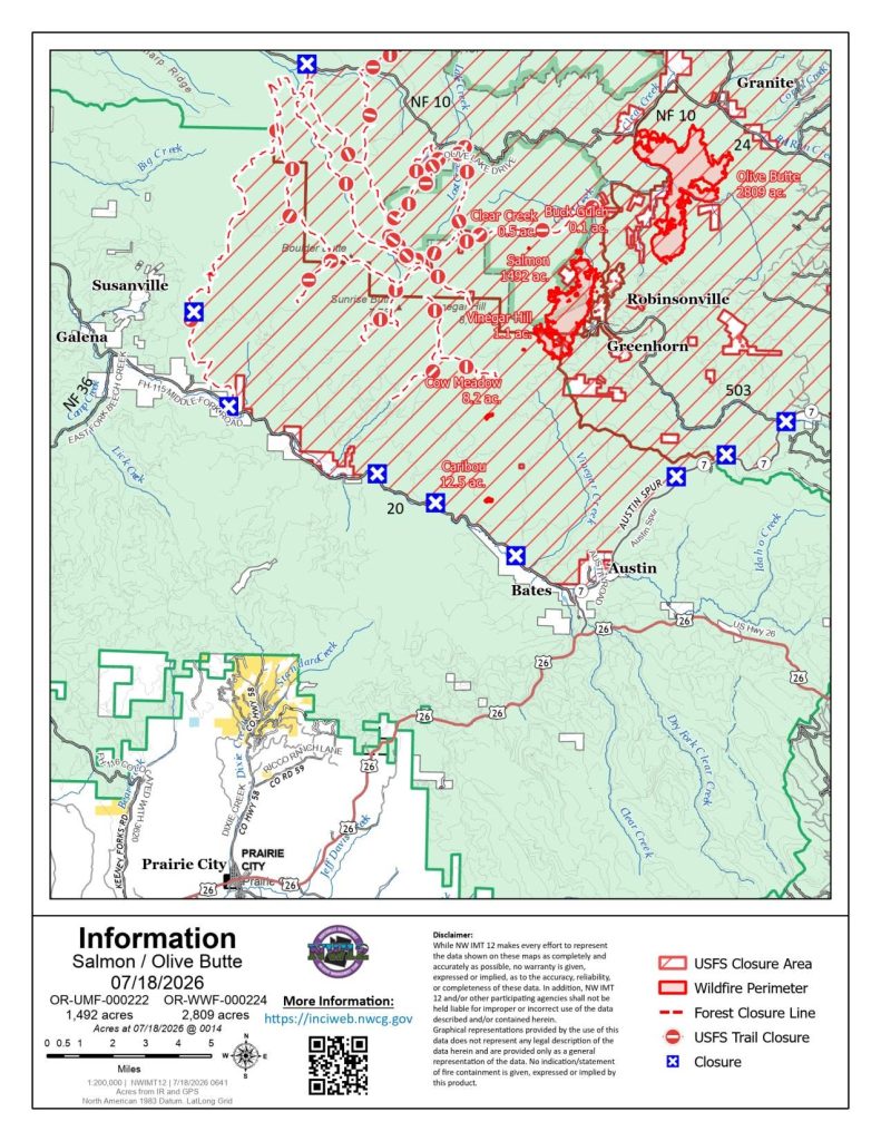
Lightning storms earlier this month ignited several fires in Oregon’s rugged northeastern wilderness.
The Salmon Fire has burned nearly 1,500 acres and is about 15% contained, while the nearby Olive Butte Fire has grown beyond 2,600 acres with approximately 10% containment.
North of Baker City, the Anthony Fire has expanded to nearly 2,000 acres and remains only 8% contained.
Temporary closures remain in effect across portions of the Malheur, Umatilla, and Wallowa-Whitman National Forests, and evacuation notices continue for nearby residents.
For the latest updates, visit the official Salmon Fire OR 2026 incident page.
Jackson County
Southern Oregon continues to battle the East Evans Creek Fire, northeast of Rogue River.
The human-caused fire has now burned more than 11,500 acres and is only 5% contained. Multiple road closures remain in effect, including portions of East Evans Creek Road, West Fork Evans Creek Road, Rock Creek Road, and sections of the Tiller-Trail Highway.
Level 1, 2, and 3 evacuation orders remain active across parts of Jackson County, with some nearby areas in Douglas County also affected.
For the latest updates, visit the East Evans Creek Fire entry on InciWeb.
Jefferson and Crook Counties
Near Lake Billy Chinook, the Akawa Butte Fire has quickly grown to around 5,000 acres and remains 0% contained. Investigators are still working to determine its cause.
Nearby, the Brewer Fire, burning east of Brewer Reservoir in Jefferson and Crook counties, has also reached roughly 5,000 acres with no containment reported. Level 2 evacuations remain in place around the fire.
Umatilla County
Firefighters have made encouraging progress on the Lower Dry Creek Fire, also known as the Hoag Fire, south of Milton-Freewater. The fire had burned just over 8,000 acres and reached 57% containment, though Level 1 and Level 2 evacuation notices remained in effect.
For current evacuation boundaries and local updates, visit the Umatilla County Sheriff’s Office interactive evacuation map. Additional incident information is also available through the Lower Dry Creek Fire update page.
Farther south, the newer Hagen Fire continued burning near Bingham Road with no containment reported. Level 2 and Level 3 evacuation orders remained active as crews worked to slow the fire’s spread.
Residents near the Hagen Fire should check the Umatilla County Sheriff’s Office for the latest evacuation notices and mapped boundaries.
Wheeler County
One of Oregon’s largest wildfire responses is focused on the Rowe Complex, a group of more than a dozen fires burning near the John Day River across Wheeler, Wasco, and Crook counties.
Because the complex includes so many separate fire areas, officials were still awaiting updated infrared mapping before releasing a reliable total acreage estimate. Containment remained at 0%.
Level 2 and Level 3 evacuation orders were in effect. Residents should check the Wheeler County Sheriff’s Office and the official interactive evacuation map for the latest zone boundaries and local emergency information.
The fires also forced widespread public-land closures. The Bureau of Land Management closed areas along both sides of the John Day River, while the National Park Service closed the Clarno and Painted Hills units of John Day Fossil Beds National Monument.
Travelers can review the latest restrictions through the BLM closure information and the John Day Fossil Beds National Monument closure page.
The nearby Cove Creek Fire, burning close to the monument, had grown to an estimated 1,000 to 2,000 acres. The fire also prompted closures along Highway 218 and at the Clarno Unit.
For current evacuation notices, road closures, and incident updates, visit the Wheeler County Sheriff’s Office and Genasys Protect.
What Oregon’s Evacuation Levels Mean
If you’re traveling or living near any wildfire, it’s important to understand Oregon’s evacuation system:
- Level 1: Be Ready. Stay informed, monitor conditions, and prepare to leave if necessary.
- Level 2: Be Set. Significant danger exists. Pack essential belongings and be prepared to leave immediately if conditions worsen.
- Level 3: Go Now. Immediate danger is present. Leave without delay and follow instructions from emergency officials.
With hot temperatures, dry fuels, and additional lightning possible in the coming days, fire officials say conditions could change rapidly. Anyone with travel plans across central, eastern, or southern Oregon should check the latest road conditions, evacuation notices, and fire restrictions before heading out.