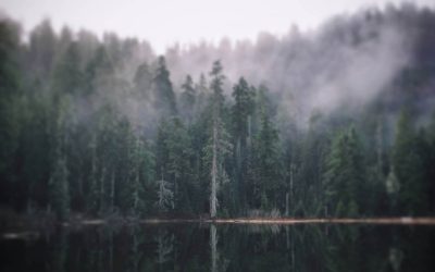
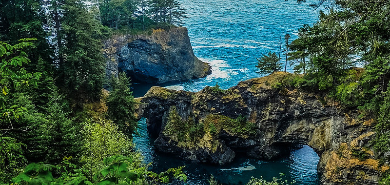
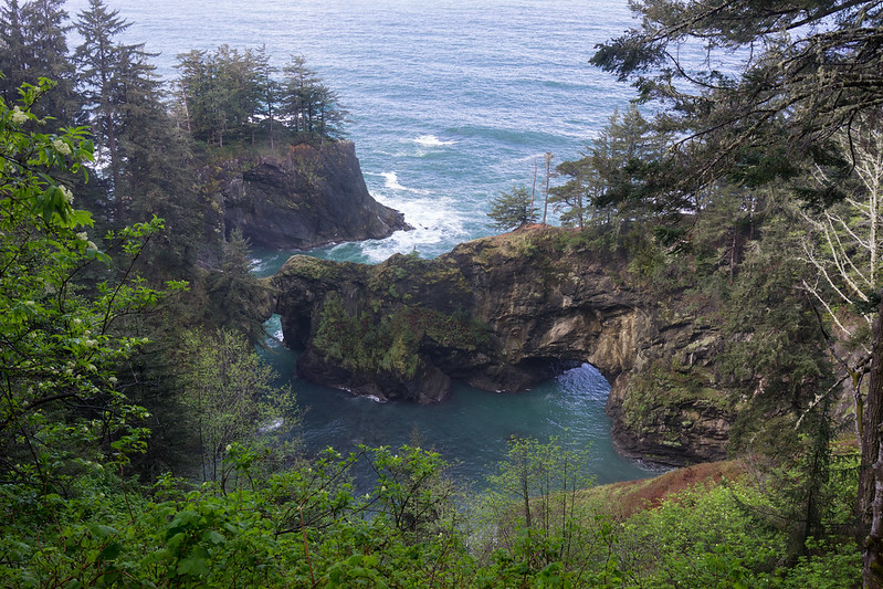
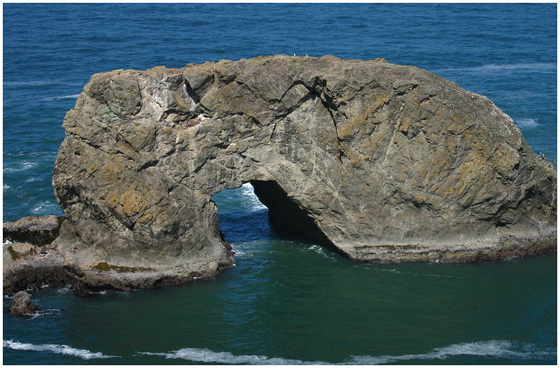
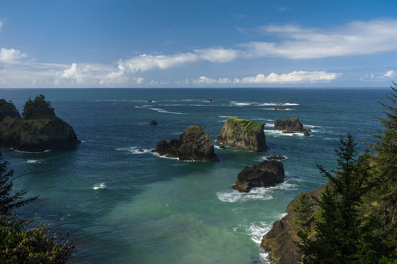
The Natural Bridges in Oregon at Samuel H Boardman State Scenic Corridor on the southern Oregon coast are a part of several geological wonders on the Oregon coast. These natural bridges look like they came straight out of a fairy tale and are absolutely incredible.
Natural Bridges in Oregon
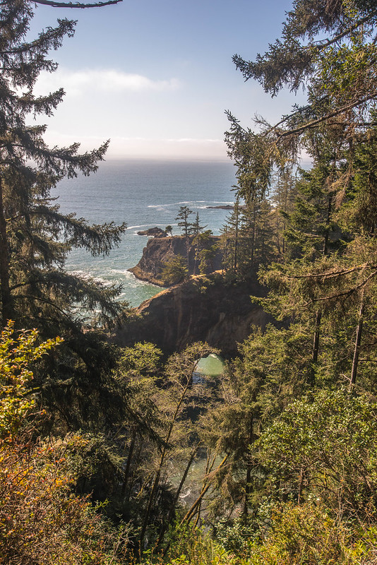
Starting out as small cracks in the rock, wind, water and waves have carved out these gorgeous natural bridges over time.
While the Natural Bridges at Samuel H. Boardman State Scenic Corridor are ephemeral and will eventually coming crashing down into the surf, it’s well worth the time to visit them while they last.
Getting To The Natural Bridges Viewpoint From Brookings Or Gold Beach
From Brookings, travel north on highway US-101 for 11.3 miles (approximately 14 minutes) to the viewpoint. The Natural Bridges viewpoint is on the left.
From the town of Gold Beach, travel south on highway US-101 for 16.8 miles (approximately 19 minutes by car). The Natural Bridges viewpoint is on the right.
The gravel parking area is small and has room for about eight cars. If you arrive at a busy time, there may also be cars parked on the side of the highway if the parking lot is full.
You can see the location of the viewing area (about 17 miles north of the California border or a 22 minute car ride) below:
Visiting Natural Bridges Viewpoint On The Oregon Coast
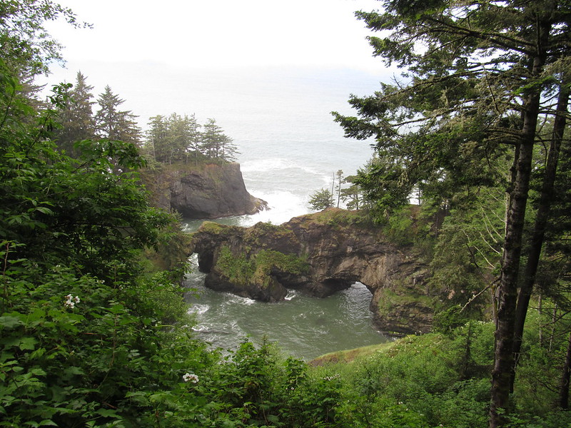
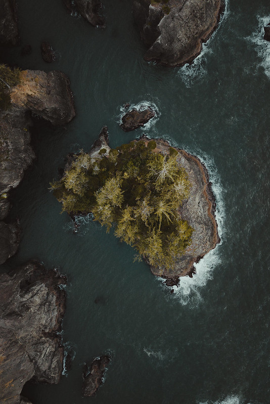
From the parking lot it’s a short walk to the viewing platform and stunning views of Natural Bridges. There are actually seven natural bridges here, but not all of them can be seen from the viewing platform.
From the viewing area there is a steep narrow pathway leading down to better views of the bridge. It is NOT recommended that you take this steep narrow pathway as people regularly die on this trail at the Natural Bridges Viewpoint. One example is this landscape photographer who slipped on the trail and fell down the 300 foot cliff and died. Another example is this woman from North Carolina who fell off the cliff into the ocean and died.
In good conditions this trail at the natural bridges is dangerous has steep drop-offs, and dozens of roots to trip on that could send you sprawling off the side of the cliff. In bad conditions the steep trail can be windy, and the trail will be muddy and slippery.
Search and rescue is frequently called to this spot at the natural bridges to rescue people and recover the bodies of those that have tried to walk down to get closer to the bridges. It’s really not worth the closeup if it means the risk of a fall from the trail and over the side of the cliff just for a photo.
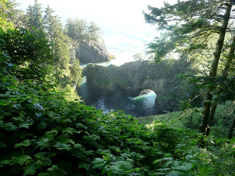
Instead, take the short walk from the natural bridges parking lot to the overlook platform and skip the narrow trail. The trail from the parking area to the viewing platform to view the natural bridges is a short easy walk.
Dr. Samuel Dicken Memorial At Natural Bridge
While you’re at the Natural Bridges, you may spot the Dr. Samuel Dicken memorial. This is the man who first envisioned the Oregon Coast Trail, a trail that stretches along the entirety of Oregon’s majestic 362 mile coastline. Known as the OCT, the Oregon Coast Trail makes it’s way through 28 coast towns, and takes hikers along some of the most scenic spots on the coast.
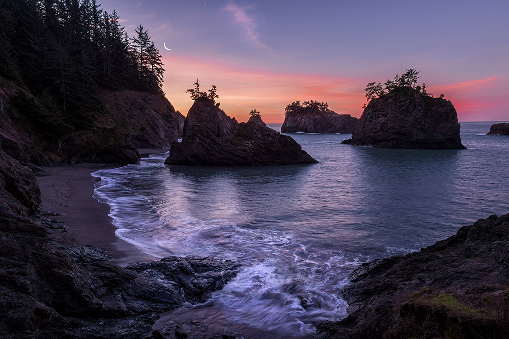
Photographing Natural Bridges Oregon
While you can snap a photo at any time of day, if you’re looking to take one of those dreamy photos we’ve all seen of this spot, you’ll need to go at the right time.
If you go too late in the day, the water and sky will be washed out in photos while the rocks of the bridges will be too dark. Early morning is a great time to go and set up your camera so you can catch the light from the sunrise.
Matt Cook Oregon has some great tips on photographing and visiting the bridge at this scenic spot:
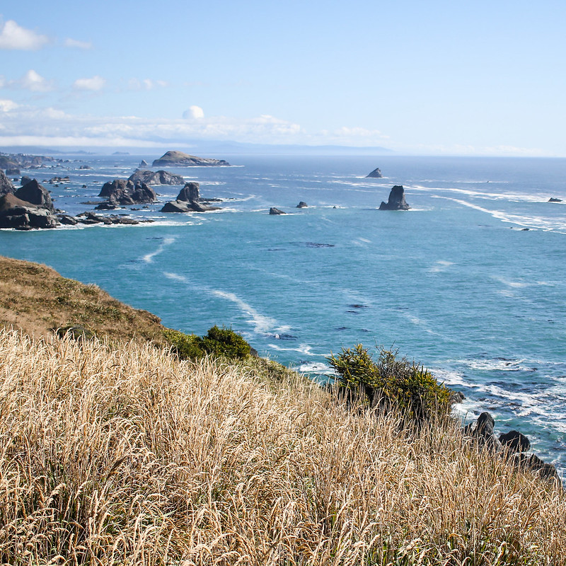
Other Scenic Spots In Samuel H. Boardman Scenic Corridor
Whether you’re just driving through on your way to Brookings, or are taking a weekend to explore, make sure you stop off at Arch Rock, Cape Ferrelo Viewpoint, House Rock Viewpoint, and Whaleshead Beach.
Samuel H. Boardman Scenic Corridor History
This park was named in honor of Samuel H. Boardman, the first Oregon Parks superintendent. He and others of his generation felt this shining green emerald coastline should be saved for the public. What gems they gave us: admire the 300-year old Sitka spruce trees, gaze at the amazing Arch Rock and Natural Bridges, and walk the 27 miles of Oregon Coast Trail that weave through giant forests. Seaside prairies, spectacular vistas, secluded cove beaches, rugged cliffs and forested sea stacks come one after the other at this park. Visit old mining sites. Stand and ponder the old shell middens and wonder what it was like to live in a Native American village by the Pacific Ocean.
Samuel H. Boardman State Park?
Is it a state park or a state scenic corridor? Samuel H. Boardman is officially a state scenic corridor.
Driving The Samuel H Boardman State Scenic Corridor
Looking for tips on driving the Samuel H Boardman Scenic Corridor? We have a full guide for you right here. There’s so many awesome things to stop and see here. The Samuel H Boardman State Scenic Corridor is truly one of the gems of the southern Oregon coast.
Visiting Arch Rock In Samuel H Boardman Scenic Corridor
There’s a paved parking area with a short hiking path to a scenic viewpoint (we recommend going at sunset). The walking path to the viewing area will take you to a great spot to check out a series of sea stacks and pretty little islands in the ocean.
Arch Rock is a massive rock standing sentinel over the Pacific. This is one of many natural arches along Oregon’s rugged south coast, eroded by wind, water and time.
There’s a little area with picnic tables if you want to stop and have lunch while visiting Arch Rock.
The short path to the viewpoint is only .3 miles and easy to walk. If you’re looking to go hiking, we’d suggest the hidden trail to Secret Beach.
Hiking The Path To Secret Beach
Not far from Arch Rock is a hidden trail to Secret Beach. The trail is unmarked, though it’s probably one of the worst kept secrets in Oregon.
Approximately 6 miles South of the Arch Rock viewpoint is the trailhead to Secret Beach. The trail is 1.6 miles, though the video below claims it’s shorter.
The hike down this path is steep, but doable, and the trail is considered moderately challenging. Expect the path to be muddy after a good rain.
From the beach you’ll see some of the islands and possibly the arch to the north. Sunset is a great time to visit, but you should be aware of the tide and when it’s coming in and out. You should not be on the beach when the tide is coming in.
Visiting Cape Ferrelo Viewpoint In The Samuel H Boardman Scenic Corridor
If you’re looking for a good hike, we suggest taking the mile long hike at Cape Ferrello Viewpoint. This hike shows off a rugged and breathtaking coastline and if you’re there late in the day, a jaw dropping sunset. This also happens to be a great spot for whale watching.
Visiting Nearby Brookings, Oregon
Brookings is a great spot to stop and stay when visiting the many natural arches on the south coast, coming to hike, or going to the beach. Brookings is around 11 miles south of Natural Bridges.
RELATED: Your Guide To Brookings Oregon – Fun Things To Do
Tips For Exploring Samuel H. Boardman State Scenic Corridor And The Natural Bridges
Stick to the viewing platforms where available.
Avoid narrow steep trails as they are dangerous. If you do choose to take these trails, be careful and stay away from the edge.
Do not climb on the natural bridge at the viewpoint or on any other natural rock formations.
Bring binoculars to search for wildlife and get an up close look at some of these gorgeous rock formations.
Never hike beyond your skill level or ability, or where it’s not safe.
Please follow the seven easy principles of Leave No Trace when out exploring Oregon’s natural areas to help keep them open for future generations.
Have you ever seen a natural bridge formed by erosion? Have you ever been to the Natural Bridges in Oregon at sunrise or sunset? What did you think? Did you grab any stunning photos? Share your pictures of the Natural Bridges with us, and tag the friends and family you want to go on a trip to the coast with!