There are places that feel like destinations.
And then there are places that feel like they belong to you.
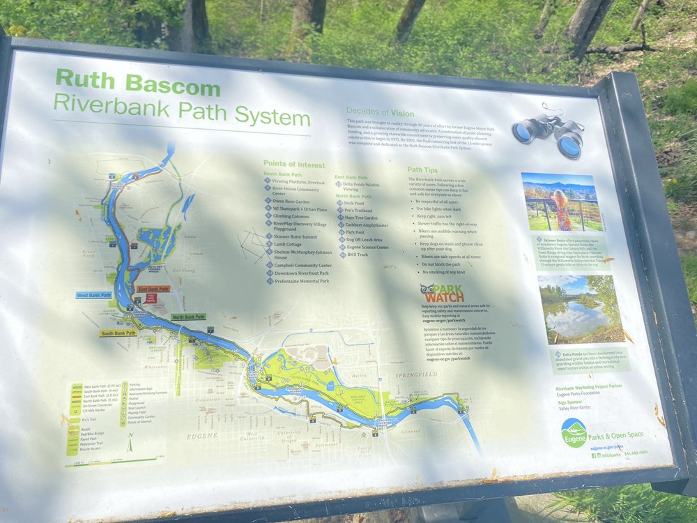
The Ruth Bascom Riverbank Path System is not flashy, but it's also one of the first of its kind in the country. It is not remote. It does not require a tank of gas or a packed weekend bag. It is simply there, flowing beside the Willamette River, quietly stitching Eugene and Springfield together mile by mile.
And once you ride it, it becomes yours too.
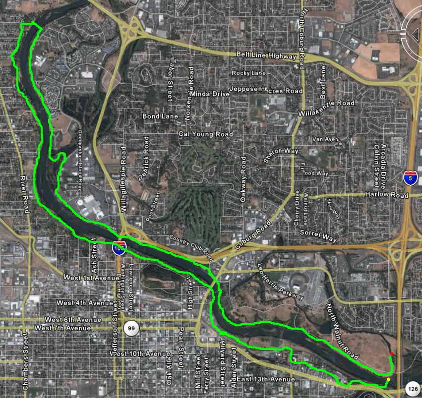
The full path system stretches roughly twelve miles along both sides of the Willamette River. But what makes it so special is not just the distance. It is the way the trail moves through parks, under bridges, beside cottonwood groves, and past neighborhoods in a way that feels seamless and intentional. You can start almost anywhere. You can ride a short loop or spend half a day exploring.
If you are visiting from out of town, one of the easiest and most scenic places to begin is Alton Baker Park in Eugene. There is ample free parking throughout the park, including near Pre’s Trail and the Cuthbert Amphitheater area. From there, you can hop directly onto the paved river path and head east toward Springfield or west toward downtown Eugene and Skinner Butte.
Another beautiful starting point is Island Park in Springfield. Park near the community center or along D Street and you will find direct access to the path as it curves along the riverbank. This section tends to feel slightly quieter, with open grassy areas and wide river views.
If you prefer a downtown launch, you can begin near Skinner Butte Park in Eugene. There is parking available at the base of the butte, and from there you can ride along the river and quickly connect into the larger path network.
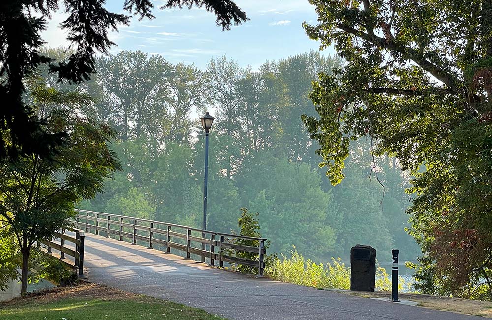
What makes the system unique is that it is not a straight shot out and back. The trail includes multiple segments including the North Bank Path, South Bank Path, East Bank Path, and connections that allow you to cross the river several times. The footbridges are wide, bike friendly, and offer some of the best vantage points along the route.
You can easily create a loop ride by crossing at the DeFazio Bridge near Valley River Center and returning along the opposite bank. For a longer adventure, ride from Alton Baker Park east into Springfield, cross over near Island Park, and return on the other side. If you connect all major segments and crossings, you can comfortably build a ride close to twelve miles without ever repeating the same scenery.
The path is paved, mostly flat, and suitable for nearly all skill levels. Families with young children ride it regularly. Strollers and mobility devices navigate it with ease. There are no steep climbs and very few technical sections. This accessibility is part of what has made it so beloved.
Along the route, you will find restrooms at several major parks including Alton Baker Park and Island Park. Drinking fountains are available seasonally. Benches appear frequently enough that you can pause whenever the view calls for it. If you ride near Valley River Center, you are only a short detour from coffee shops and restaurants. Downtown Eugene is never far from the western sections of the trail, making it easy to grab a pastry or lunch before or after your ride.
But beyond the practical details, something else happens when you get out there.
The river begins to guide you.
A Trail That Feels Like an Escape Without Leaving Town
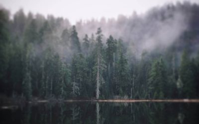
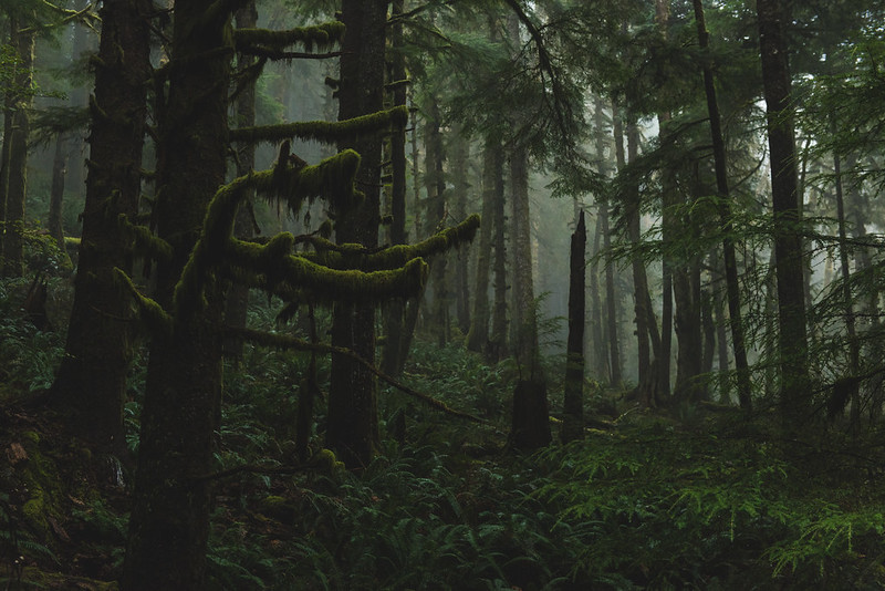
The Willamette River is not just background scenery on this ride. It is the steady companion that shapes the entire experience.
In the early morning, mist rises from the water in soft layers. The light filters through tall trees and casts long shadows across the pavement. You may pass serious runners logging miles before work, or retirees walking in pairs, talking quietly about nothing and everything. The world feels slower here.
By midday, the path hums with life. Cyclists in bright jerseys glide past. Parents tow toddlers in colorful bike trailers. College students ride toward campus, cutting through green space instead of sitting in traffic. Dogs trot happily beside their humans. The bridges overhead frame the river in wide, open arcs.
The DeFazio Bridge, with its distinctive white cables, offers one of the most iconic crossings. From its center, you can look both directions and see how the river curves through the heart of Eugene. Cross here and you instantly feel the connectivity that makes this system special.
Further east, the Frohnmayer Bridge near Autzen Stadium gives another sweeping view. On game days, you might see fans walking nearby. On quiet weekdays, it feels like a private overlook suspended above water.
Season by season, the trail transforms.
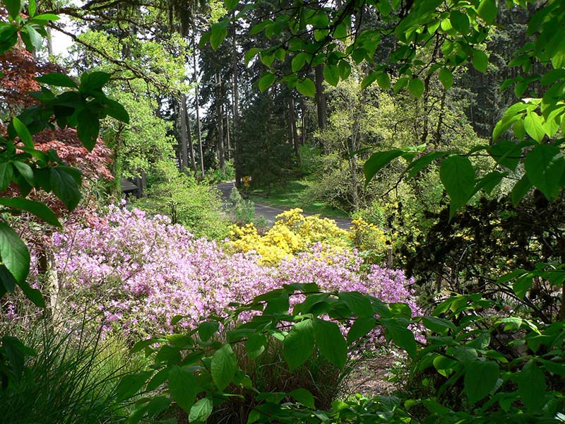
In spring, the valley bursts into green. Wildflowers appear along the edges of the path. The river runs fuller from snowmelt. The air smells fresh after rain. Riding through this landscape feels hopeful, almost electric with renewal.
Summer stretches the evenings long and golden. The river reflects pink and orange skies. Families gather in Alton Baker Park. You might ride until nearly nine at night and still catch light on the water. The pavement radiates warmth. Everything feels expansive.
Fall drapes the trail in amber and rust. Leaves scatter across the path in soft layers. The river mirrors fiery trees. There is a crispness in the air that makes every breath feel sharp and invigorating. It is the perfect season for long, reflective rides.
Winter quiets everything. Mist clings to the water. Fewer riders venture out. The sky often turns silver gray, and the entire path feels hushed. There is something deeply peaceful about riding here in the colder months. It feels intimate, almost sacred.
For locals, the trail holds memories layered over time.
First bike rides without training wheels. Training runs before high school meets. Walks after difficult days. Conversations that changed the direction of a life. It is not just a recreation corridor. It is woven into the daily rhythms of Eugene and Springfield.
The path also reflects the region’s commitment to outdoor living. Eugene has long embraced cycling culture. The river path supports commuting, fitness, and leisure all at once. It proves that infrastructure can be beautiful. That urban planning can prioritize connection over congestion.
Back in the 1970s, when most American cities were building wider roads and prioritizing cars, Eugene did something different. The river path was intentionally designed as a bicycle transportation corridor. Not just a recreational trail, but a functional, everyday route for people to move through town without a vehicle.
The Ruth Bascom portion became one of the first projects of its kind in the country. A paved, continuous corridor built specifically with bicycles in mind. Today, that original vision still shapes how the community moves.
The twelve mile loop runs along both sides of the river, but it does not stop there. In Springfield, it connects to the Clearwater Path, a beautiful stretch that offers open views of the mountains and the meeting point of two rivers. Ride that direction and you can add roughly three to four miles each way, turning a casual outing into something more expansive.
Head west and the system links into the 6.9 mile Fern Ridge Path, stretching into the West Eugene Wetlands. Out there, the landscape opens wide. Birds lift from the marsh. The sky feels enormous. It is hard to believe you are still within reach of town.
Together, these connected corridors form something larger than a simple park trail. They create a network. A transportation system powered by legs instead of engines. A daily rhythm built on movement and intention.
If you want to ride the entire system in one outing, plan for two to three hours at an easy pace with stops. Bring water, though fountains are available in warmer months. Start at Alton Baker Park, head east into Springfield along the North Bank, cross at Island Park, return along the South Bank, and then continue west toward Skinner Butte before looping back across the DeFazio Bridge. This route gives you a comprehensive feel for both cities and the full river corridor.
For families with younger children, the stretch between Alton Baker Park and Valley River Center tends to feel wide and gentle with plenty of open views. For quieter stretches, head east of Autzen Stadium toward Springfield where traffic noise fades and river sounds take over.
And perhaps the most beautiful part of this trail is that you do not have to conquer it.
You simply experience it.
It does not demand endurance. It does not test your limits. It welcomes you exactly as you are. Whether you ride one mile or twelve, whether you move quickly or slowly, the river remains steady beside you.
It may not be nationally famous like cross state rail trails that draw destination cyclists from across the country. But here in Oregon, it is quietly iconic. It defines daily life in ways that outsiders might never fully understand.
The Ruth Bascom Riverbank Path System is not about bragging rights. It is about belonging.
It is about feeling connected to water, trees, sky, and community all at once.
And once you ride it, you begin to see Eugene and Springfield differently. Not as separate cities divided by a river, but as neighbors joined by one long, beautiful ribbon of pavement.
All you have to do is show up.
The river will take care of the rest.
If you are coming from Portland, the drive south is simple and beautiful. Take Interstate 5 South for about two hours until you reach Eugene. Exit at Beltline Highway West toward Highway 126 and follow signs for Eugene. From there, you can head toward Alton Baker Park, which sits just across the river from downtown and offers some of the easiest access to the trail system. The drive is smooth and direct, making this an easy day trip from the city if you leave in the morning and plan to linger by the river in the afternoon.
For visitors coming from Bend, the journey feels a bit more scenic and winding. Take Highway 126 West over the Cascades. Depending on the season, you will pass through stretches of forest, mountain views, and the McKenzie River corridor before descending into Eugene. In winter months, always check road conditions over the pass. Once you reach town, follow signs toward downtown Eugene or Alton Baker Park. The park makes a natural starting point after that mountain drive, offering wide open green space to stretch your legs before you begin riding.
If you prefer entering from Springfield when arriving from either direction, Island Park is another excellent launch spot. From Interstate 5, take the Springfield exits and follow signs toward downtown Springfield and D Street. The park is well marked, easy to navigate, and places you right along one of the most peaceful sections of the river path.
No matter which direction you arrive from, the beauty of this trail is how accessible it feels once you get here. There is no complicated trailhead to search for. No long gravel road. Just park, unload your bike, and within minutes you are rolling alongside the Willamette.